
Nanoplankton...................................................................................................................................................................................................Nanoplancton
Nanoplâncton / Nanoplancton / Nanoplankton / 应用 / Карликовый планктон / Nanoplancton /
Planktonic marine organisms with dimensions between 2.0 and 10 μm (μm). Note, that a human hair has a thickness of about 100 microns (0.00010 m).
See: « Benthos »
&
« Megaplankton »
&
« Foraminifera »
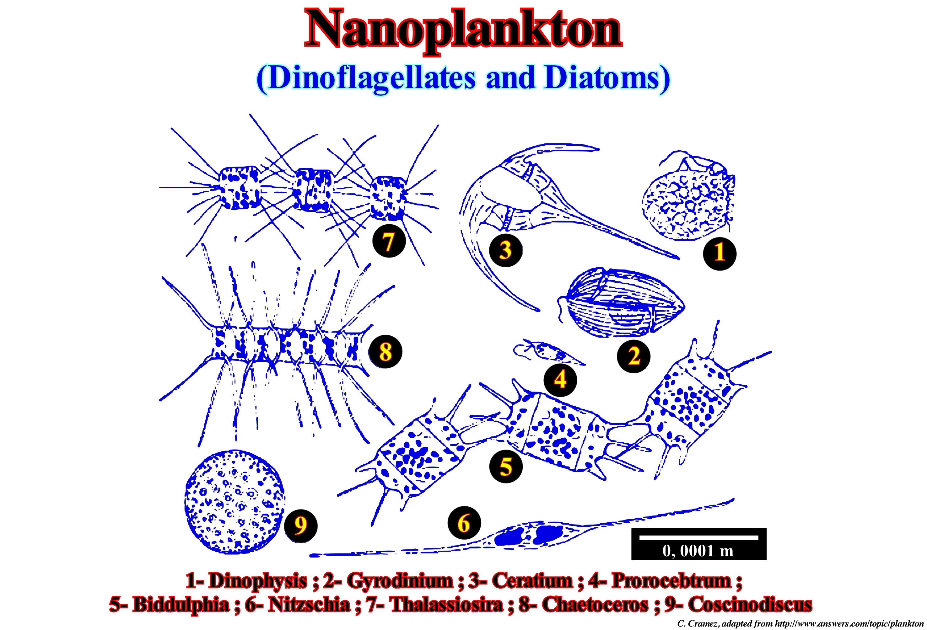
In marine biology and limnology is called plankton (from the Greek word planktos, meaning wandering) to the set of organisms that have little locomotion power and live freely in the water column (pelagic) being often dragged by the ocean currents. Plankton is at the base of the food chain of aquatic ecosystems. It serves as food for larger organisms. It was at the end of the fourteenth century that the German biologist Johannes Müller, in an ocean expedition, decided to pass a fine net of silk across the surface of the sea, to capture the substances in suspension. He found a community, totally unknown, made up of innumerable plant and animal organisms. Who first used the term plankton was the German biologist Viktor Hensen in 1887. He defined these organisms as all organic particles "floating freely and involuntarily in bodies of water, independent of the coast and the bottom." Plankton is, generally, subdivided into: (i) Phytoplankton - consisting mainly of microscopic algae ; (ii) Ithioplankton - formed by larval or juvenile forms of the locust with little locomotion ; (iii) Zooplankton - formed by animals. Phytoplankton is present in sparse oceanic water-bodies at much lower concentrations than in the water near the coast. The reason is, basically, the smaller amount of nutrients present in ocean waters, coastal waters are much richer in nutrients because the flow of nutrients from the rivers enriches nitrates, phosphates and other minerals that absent limit the development of plant biomass phytoplankton. Phytoplankton occurs from the surface to the compensation layer, in clear ocean waters this can reach more than 80 meters deep. The compensation layer is one in which the vegetable can photosynthesize only enough to stay alive for the maintenance of its metabolic processes. From this layer the vegetable consumes more energy than it produces and ends up dying from starvation. (http://en.wikipedia.org/wiki/Plancton).
Narrow (Gut).......................................................................................................................................................................................................................................................Goulet
Golada / Pequeño estrecho / Enge / 窄 / Узкий проход / Stretto /
Tight passage between two water-bodies, such as between the islands or shallows (ford), or the depression that connects a lagoon to the sea, in general, with very strong currents.
See: « Channel »
&
« Lagoon »
&
« Stream »
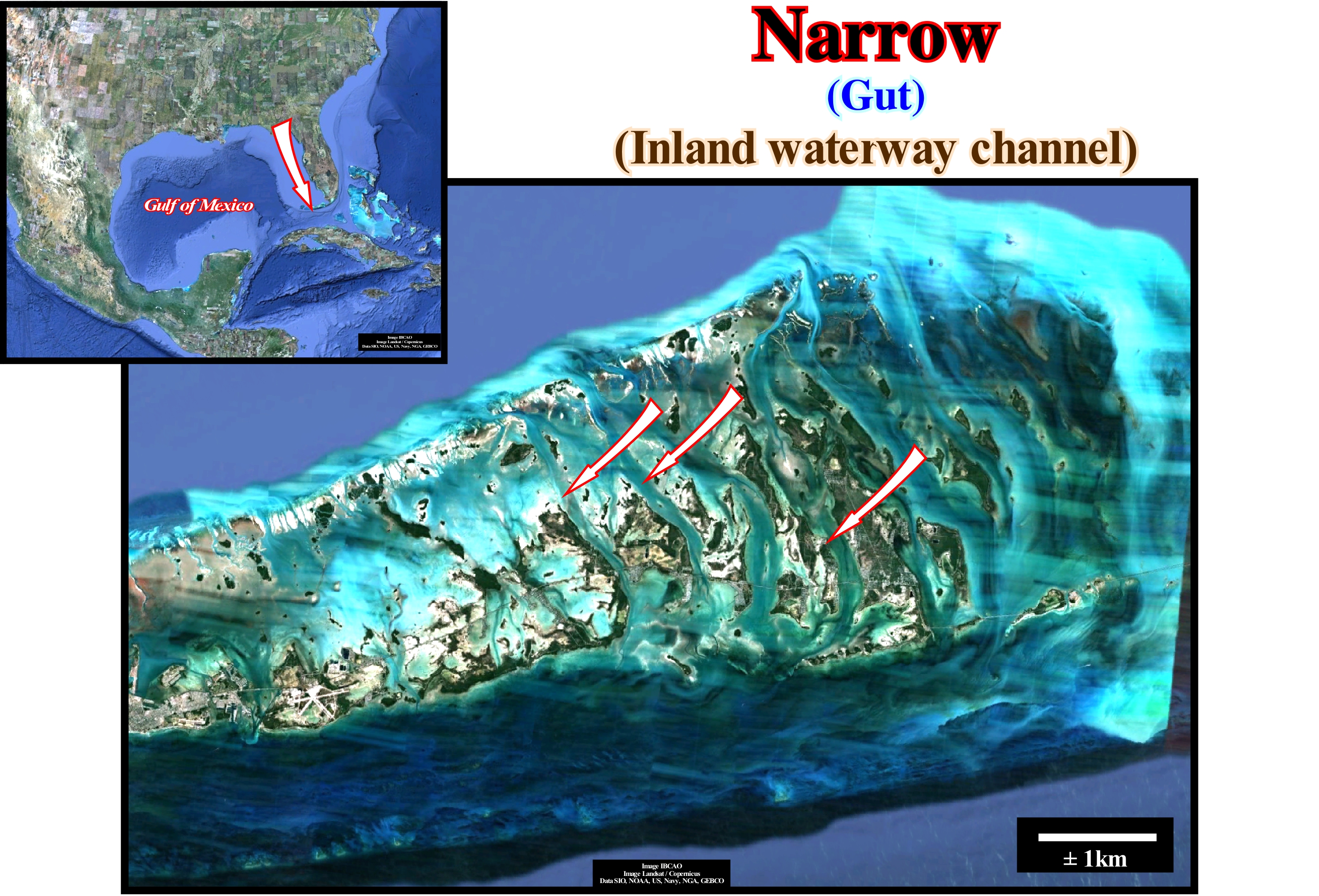
Many geoscientists consider a narrow (gut) as a synonym for a channel : "In this context, narrow, is the navigation channel, at the ends of the sandbanks of a bar, passable by small boats" (http://letratura.blogspot.com / 2009 / 05 / lexico-golada.html). We prefer to consider a narrow a depression between two water-bodies that under certain conditions and at certain times allows the flow of water from one body to another. In the short term, function of the tidals, the bottom of a narrow can be, totally, exhumed, which very, rarely, happens with a river channel. On the other hand, a narrow or gut exists even when the islands or the low ones are covered of water, that is when the two water-bodies unite. On the other hand, a canal can be: (i) Totally natural as the channel of a river or any other water-stream ; (ii) Fully artificial, as an irrigation channel ; (iii) Partially artificial, such as channels linking existing water-bodies such as the Suez Channel and (iv) Mixed with artificial portions and channelled rivers, for example the channel from Nantes to Brest (France). In geology, and especially in sequential stratigraphy, the term channel, which serves as the conduit for the water and particles it carries and is defined by the wet section that allows the flow, is very confusing. In fact, many geoscientists call the channel not only the stream-bed, but also its filling. This is especially frequent on the tentative geological interpretation of seismic lines or electrical logs, where the great majority of geoscientists identify, for example, shaly channels or sandy channels, which is a huge error of language, since there is confusion between the bed of the old current and the sediments that fill it. In geology, a shaly channel is a channel that has been incised in shaly sediments and not the filling of an old carved channel, for instance, in carbonated rocks, which was later filled by shaly sediments when a relative sea level rise flooded the incised valley. A similar language error is very common in deep turbidite environments. Many of the so-called turbiditic channels are, actually, late fillings of the depressions between the turbidite lobes.
Natural Arch.....................................................................................................................................................................................................Arche naturelle
Arco Natural / Arco natural / Natürlichen Bogen / 自然的拱形 / Естественная арка / Arco Naturale /
Arch excavated on a promontory by the sea, although there are natural arches formed by subaquatic and fluvial geological processes.
See: « Stack, Pinnacle »
&
« Skerry »
&
« Promontory »
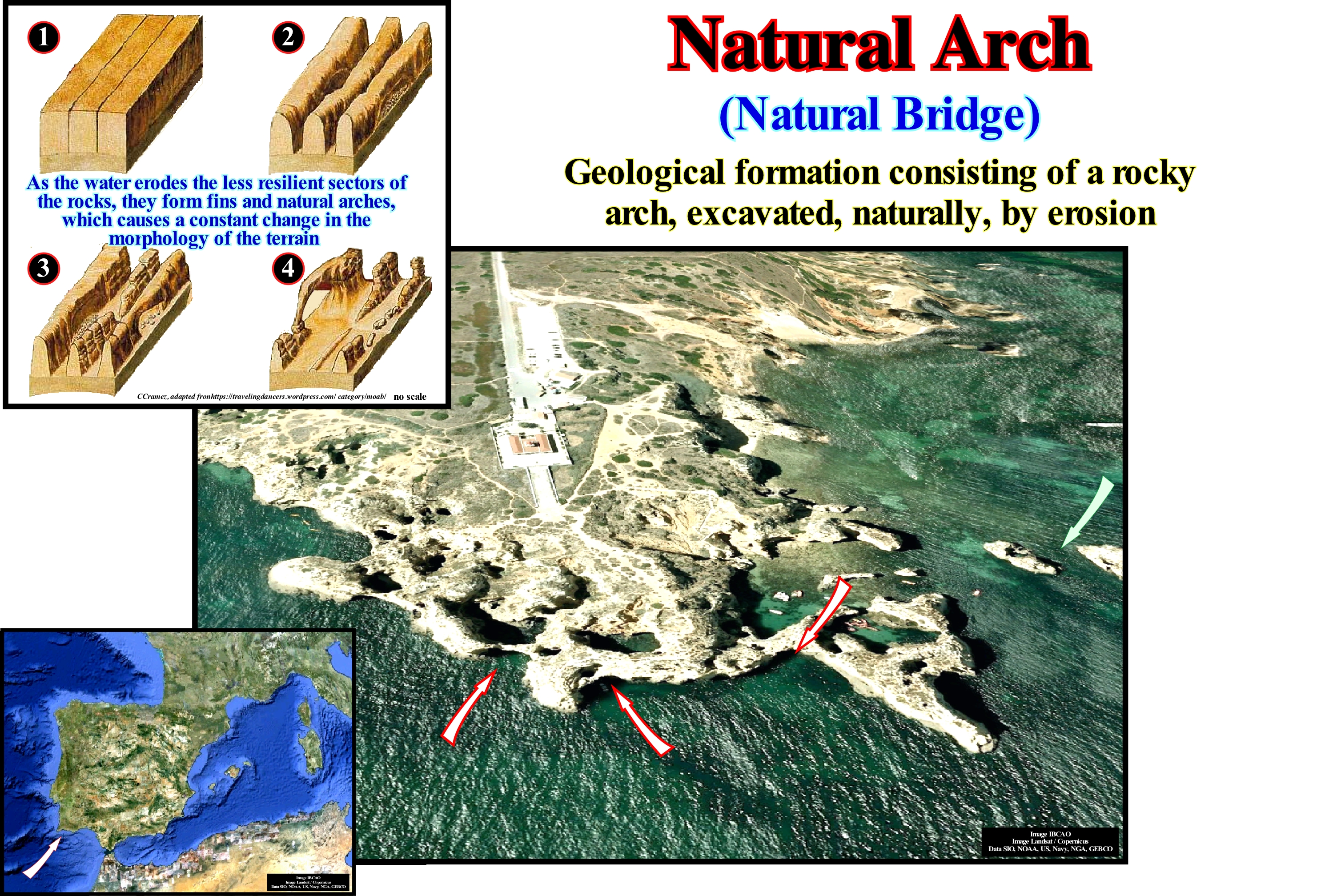
A natural arch, which is also called natural bridge, is a tunnel formed on a rock, which allows a passage through it. This is not the case of a cave, although under certain conditions it may be considered as a stage of the formation of an arch. This is very visible in the Google image of this figure, in which, along the coast, caves are recognized and natural arches are guessed. Natural arches, stacks or pinnacle (isolated cliffs near the coast) and skerry (cliffs near the water surface not far the shoreline) are visible a few hundred meters from the coast. It is easy to conjecture that, in this area, there was an old cliff (not confuse cliff and promontory*), more or less perpendicular to the coastline (as the cliff residue visible in the right part of the image), destroyed by the action of the vacancies, leaving important passages between the stacks and skerries. The natural arches are, preferably, formed when the cliffs are, heavily, subject to the erosive action of the sea, rivers or subaerial alteration. Erosive agents attack the less resistant parts of the rocks that form the cliff, creating areas and forms of corrosion that become ever larger. Finally, when the more resistant parts of the rocks that were not eroded can no longer bear the weight of the rocks overhanging the cliff begins to collapse. On discordant coasts (when the rocks are oriented more or less perpendicular to the coastline), the refraction of the sea-waves concentrates the energy in the promontories and the natural arches form when the caves break the promontories, individualizing stacks and skerries. On the concordant coasts (when the rocks are oriented more or less parallel to the coastline), when there is an alternation of resistant layers and low resistance layers, the action of the waves, easily, erodes the less resistant rocks, formed small caves that they grow little in size, and when they collapse they create coves (open recesses of the coast towards the sea, usually limited by two higher portions), more or less important.
(*) A cliff is a coastal geographic form, characterized by an abrupt encounter of the land with the sea, whereas a promontory is a prominent land mass that protrudes from the lower lands on which it rests or protrudes from a water-body. In this last case, the geoscientists speak of peninsula or of cape.
Natural Gas.......................................................................................................................................................................................................................Gaz naturel
Gás natural / Gas natural / Erdgas / 天然气 / Природный газ / Gas naturale /
Hydrocarbon arc composed of 1 to 5 carbon atoms and exists either as gas or vapour at normal temperatures and pressures. The most common natural gases are: (i) Methane; (ii) Ethane; (iii) Propane, etc. The natural term, imposed by certain ecological lobbies, is a bad fit. With the exception of synthetics, all hydrocarbons are natural and when burned they produce all CO2. The amount of CO2 produced by the use of gas as a fuel to produce energy is only 20% lower than that produced by oil (all other conditions are equal), which many people ignore.
See: « Methane »
&
« Biogenic Gas »
&
« Synthetic Natural Gas (SNG) »
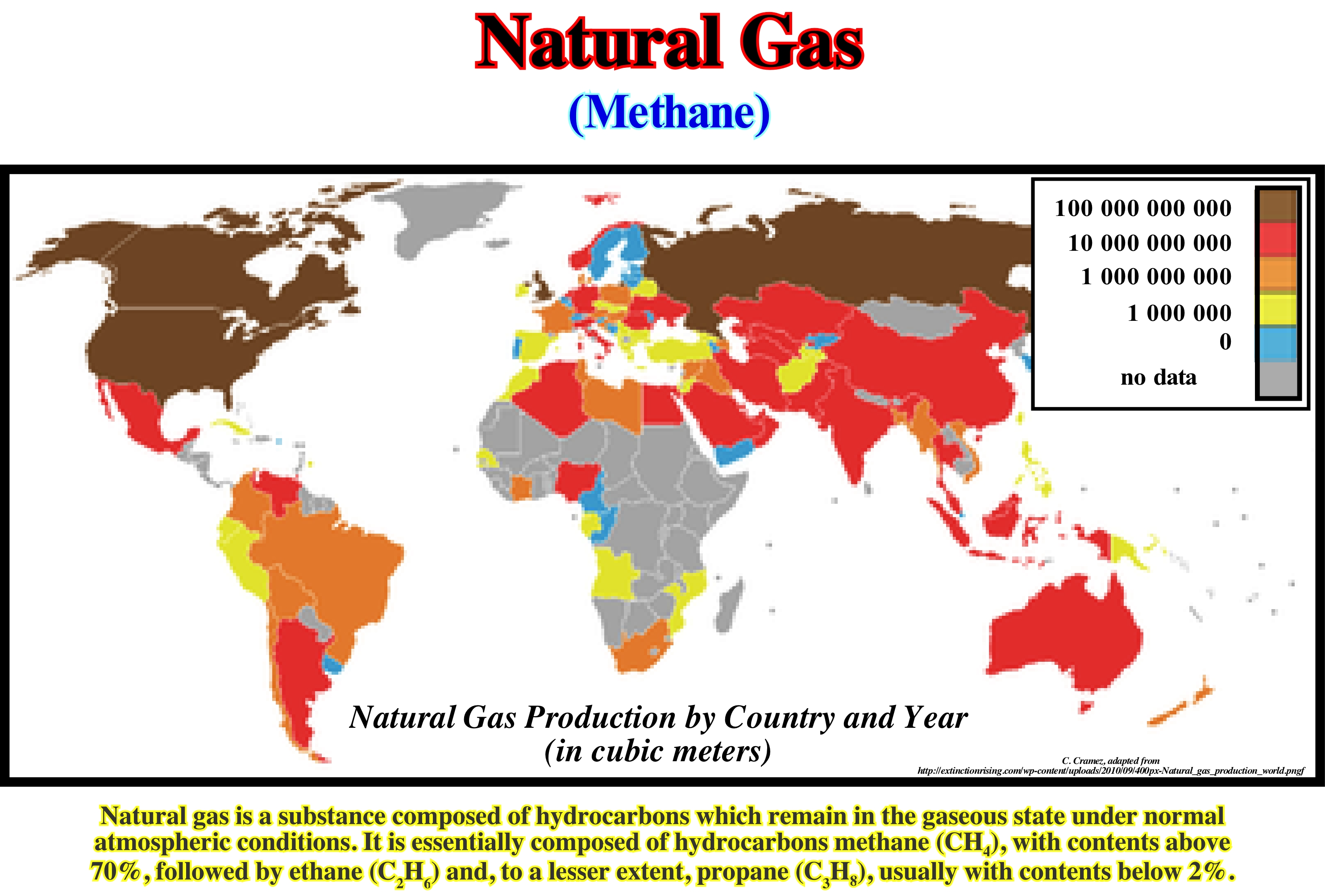
The largest gas field in the world is the North field in Qatar offshore. Reserves are estimated at about 35 trillion cubic meters (± 900 Tcf*) of gas "in situ", which corresponds to about 200 years of production (not to be confused with consumption) at the current rate. The second largest field is Pars South offshore Iran (Persian Gulf), which is, in fact, more or less connected with the field of Qatar. The estimated reserves ("in situ") are about 8-14 trillion cubic meters, that is between 280 and 500 Tcf**. In equivalent barrels the reserves of the North Field of Qatar, they surpass all known reserves of Iraq, for example. The greatest difficulty in using natural gas as a fossil fuel is transportation and storage because of its low density. The pipelines are economical in onshore, but, practically, impossible in offshore. In North America, pipelines carry the maximum capacity. Special vessels can carry liquefied natural gas (LNG) through the oceans. Tank trucks may carry compressed (CNG) or liquefied natural gas (LNG), but for, relatively, short distances, either directly to the users or distribution points. All of this is very costly since, on a large scale, in relation to the transport of oil, additional facilities, i.e., liquefaction or compression, are required in the production area, then transport, and facilities for degassing or decompression before gas can be sent to users. It is important not to forget that the gas is colourless and odourless, that is to say, in relation to petroleum, it pollutes more discreetly, but some producing countries lose between 10-20% of the reserves during transportation (leaks in the pipelines).
(*) A 'Trillion Cubic Feet" or Tcf is a measure of volume used in the oil industry. One trillion cubic feet (1000000000000 = 1012 cubic feet) is a measure of the volume of natural gas equivalent to approximately one Quad. A Quad is the abbreviation for a quadrillion (10 billion or 10,000 trillion) Btu. A Btu (British Thermal Unit) is a unit of energy measurement, which represents the amount of heat needed to raise the temperature of a pound of water by one degree Fahrenheit.
(**) in English 1 x 10¹² is a trillion, but in French « un trillion ou milliard de milliard» is 1 x 1082. 1 x10⁹ in English is a billion, in French is « a milliard ».
Natural Greenhouse * Effect............................................................................................................Effect de serre naturel
EEfeito de estufa natural / Efecto invernadero natural / Natürlichen Treibhauseffekt / 自然的温室效应 / Природный парниковый эффект / Effetto serra naturale /
Warming of the terrestrial surface produced by the return of the infrared rays. The atmosphere, which is composed, mainly, of nitrogen and oxygen, is transparent to the sun's rays. Most of the solar radiation, which is not reflected by the clouds reaches, directly, the Earth' surface, which causes its heating and, subsequently, the emission of infrared rays. Oxygen and nitrogen are also transparent to the infrared rays emitted by the Earth, but the atmosphere contains traces of other gases that are not transparent to these rays. These gases, known as greenhouse gases, absorb the infrared radiation emitted by the Earth and radiate them not, only, into space but, also, towards the Earth by heating it to a higher temperature than it would have had there were no gases of greenhouse effect.
See: « Unnatural Greenhouse Effect »
&
« Global Warming »
&
« Astronomical Theory of Paleoclimate »
The Earth that receives solar radiation works as a black body**, i.e., as an object that absorbs all the light it receives. No electromagnetic radiation passes through a black body and none is reflected. As no light is reflected or transmitted, the object appears black when it is cold. However, when the Earth receives the radiations from the Sun, it heats up and becomes an ideal source of thermal radiation. Assuming that the space, atmosphere and Earth are three independent systems, each of them must be equilibrium. Each system must gain and lose energy at the same speed. Such a balance is not just automatic, but regulated by itself. If the atmosphere or the Earth, at a certain moment, are destabilized, each of them will warm up or cool down until the balance is restored again. Each square meter of the outer surface of the atmosphere receives about 343 watts of solar energy, per year, of which approximately 17% is reflected by clouds, 6% by Earth and 8% by air. The remaining part is transformed into infrared radiation and returned by Earth to the atmosphere and into space. A large majority of independent geoscientists (those who refuse wages to say what the bosses want them to say) do not believe in the concept of a greenhouse effect, which for them is based on a false analogy***. They think that the physical phenomenon, whether it is in a greenhouse or on Earth, is convection. Others, such as Svensmark (2004), think the greenhouse effect is of some importance, but those who are certain that the rise in Earth’s temperature is due to CO2 never present any scientific justification, but only simple assumptions. For some geoscientist, it is the increase in temperature that increases the content of CO2 and not the other way around.
(*) The term "greenhouse effect", although consecrated, is by no means correct. In an oven, the thermal conduction of the walls and the confinement of the air increase the temperature, even when the glass is replaced by a material transparent to visible radiations and infrared radiation (as is the case of halite). The atmosphere has nothing to do with a greenhouse, since the air is not confined and can cool gracefully to the phenomena of convection. However, the atmosphere produces radioactive heating since certain gases (water vapour, methane, CO2, etc.) that compose the atmosphere absorb the infrared radiation. This is why some geoscientists prefer to speak of a "radioactive greenhouse effect" in order to emphasize that only radioactive phenomena are taken into account (A. Foucault, 2016 Climatologie et Paléoclimatologie, Dunod, ISBN 978-2-10-75460 -1).
(**) If a perfect black body, at a certain temperature, is surrounded by other objects in thermal equilibrium, it, on average, will emit, at each wave-length, exactly what it absorbs. A black body at temperature T emits exactly the same wave-lengths and intensities, which will be present in an equilibrium environment at temperature T and that would be absorbed by the body. Since the radiation in such an environment has a spectrum which depends only on temperature, it can be said the temperature of the object is, directly, related to the wave-lengths of the light it emits. At room temperature, black bodies emit infrared light, but as the temperature increases, they begin to emit at visible wave-lengths of red, orange, yellow, and white before ending in blue, in addition to which emission includes increasing amounts of ultraviolet. It is important to remember that Stefan-Boltzmann's law (or Stefan's law) states that the total energy radiated per unit area of a black body in unit time (black body irradiance, energy flux density, radiant flux or emitter power), is directly proportional to the fourth power of the thermodynamic temperature T of the black body (also called absolute temperature).
(***) The Swiss naturalist, Horace Bénédict de Saussure, at the end of the eighteenth century, put thermometers in five glass boxes embedded in each other and placed everything in the sun. He noted a significant increase in temperature in the thermometers from the outer case to the inner case. Given such a rise in temperature, he conjectured that the glass absorbed solar energy and suggested that the Earth's atmosphere could behave in the same way with respect to solar radiation. Later, in 1896, Swedish chemist Svante Arrhenius admitted that doubling the CO2 content of the atmosphere by a similar mechanism (greenhouse effect) would imply an increase in global soil temperature of about 4° C. Subsequently, S. Arrhenius advanced the hypothesis that the industrial age generating CO2 will generate global warming. According to Saussure and Arrhenius, the temperature of the glass in a greenhouse, which is at the same time the entrance doors of the solar rays and the doors that do not let out infrared rays, must be higher or at least equal to the temperature inside the oven. However, they never tested the hypotheses they advanced. Robert William Wood (1868-1955) tested such a conjecture and the test results refuted the hypotheses advanced by Arrhenius and Saussure. Wood, replaced the glasses of the greenhouse by halite, which is transparent to the infrared rays, and realized that the temperature inside the greenhouse was about the same, i.e., he realized that the mechanism of greenhouse effect alone can not explain the increase of temperature inside a greenhouse.
Neap Tide (Apogean tide).....................................................................................................................................................Marée de mortes eaux
Marée de mortes eaux / Marea de aguas muertas / Nipptide / 小潮 / Квадратурный прилив / Marea di quadrature /
Tide occurring during lunar quadraturas, which is characterized, for each location, by minimum amplitudes.
See: « High Tide »
&
« Tide »
&
« Moon »
The neap tide is a tide, relatively, low tide of high tide or a, generally, low range between high and low tide. During the first and fourth quadrant of the Moon, periods of neap tides are created due to the way the Sun and Moon act on Earth to create tides. The opposite of a neap tide is a living or spring tide, that is, a strong tide with high and low extremes. As the tidal cycle is well known, geoscientists can predict when live and neap tides occur, as well as their amplitude. Tides are caused by an interaction of several factors. The rotational motion of the Earth plays a role, as does the gravitational forces of the Moon and the Sun. At a quadrature, the Sun and Moon are perpendicular to each other, with attractions in opposite directions. These attractions, effectively, balance each other, keeping the water level, relatively, stable. While high and low tides occur during a quadrature tide, the height difference between them is minimal. On the other hand, in a syzygy tide, the Sun, the Moon and the Earth are in syzygy, which means that they are all aligned. As the Sun and the Moon are attracting together, they generate a much greater force, creating tides, proportionately, higher and lower. During spring tides, people can take advantage of low tide to harvest various organisms from rocks that are normally covered by water, and ships depart or arrive in tide time. The Sun and the Moon are directed to create a quadrature tide, when the Moon is full moon, which occurs twice during the lunar cycle, when complete. People who want to get an idea of the tides have to see in the lunar cycle whether there will be a quadrature or spring tide. Additional information about when high and low tides will occur can be collected from organizations that provide weather and tide data. People may be aware that the topography of the Earth influences the tides, which is one reason why tide levels are not the same across the Earth, or even in a region.
Nebular Theory................................................................................................................................................................................Théorie nebulaire
Teoria Nebular / Teoría nebular / Nebular Theorie / 星云理论 / Небулярная гипотеза происхождения миров / Teoria nebular /
Theory that says the solar system formed from the contraction of a cloud of gas and dust.
See: « Big Bang (theory) »
&
« Early Universe »
&
« Sun »
The nebular hypothesis was first proposed in 1734 by E. Swedenborg and in, 1755, by E. Kant, who admitted that a nebula when rotating, slowly, upon itself condensed, gradually flattening itself by gravity, to form stars and planets . The solar nebula is a gas cloud, or accretion disk, from which the solar system formed. A similar model was proposed in 1796 by Laplace. According to this theory, the nebula would have an initial diameter of 100 AU and a mass of 2 to 3 times the current mass of the Sun. Over time, gravity caused condensation of the gas cloud (increase of pressure and density), creating a protostar in the centre of the nebula. This primitive system was heated by the friction of the molecules. The fusion appeared much later. Due to the principle of the conservation of angular momentum (which implies an acceleration of rotation during contraction), the nebula did not completely collapse on itself. It formed a protoplanetary disk in orbit around the protostar, as illustrated in this figure. Inside the system, lighter elements such as hydrogen and helium were displaced out of the central region by solar wind and radiation pressure, leaving behind the heavier elements and dust particles that formed protoplanets. On the outer side of the solar nebula, ice and gas remained more or less in the same place, forming inner planets and gaseous planets on the outside. After about 100 million years, the temperature of the protostar reached a level such that thermonuclear reactions began to occur and the proto-star became the Sun. Probably at the same time, that is, ± 4.6 Ga , the inner planets (mineral or rocky planets) were formed. The moons of the gaseous giant planets appear to have formed in the same way (agglomerating themselves from accretion discs formed around these planets). On the contrary, the Moon would have formed from the sequence of the collision of the Earth with a celestial object of a size similar to that of the planet Mars. In the late nineteenth century, the nebular theory was refuted by Maxwell, who showed that if matter of the known planets had once been distributed around the Sun in the form of a disk, the differential rotation forces would have prevented the creation of the planets.
Neck (Chute cutoff, meander)..........................................................................................................................................................................Goullote (Méandre)
Atalho de meandro / Atajo de meandro / Rutsche, Cutoff / 槽或截止, 在一条河, 跨的快捷方式 meander / Шейка меандра / Scivolo, Cut-off /
Small narrow channel through the curve of a meander formed during a flood, in which the main river flow is diverted to a depression between meander point bars. When a river cuts through, the narrow throat of a meander. Also sometimes called simply Chute Cutoff.
See: « Meander »
&
« Point Bar (fossil) »
&
« Bayline »
In this figure, it is easy to understand that a chute cutoff is associated with the rupture of the river bed near the neck of the meander. This rupture is due to the law of least effort, which controls all geological events, and which, in this particular case, forces the water current to travel less space. When a meander is abandoned, in general, a lake is formed, which is called oxbow lake. As soon as the provisional equilibrium profile of a river becomes more or less horizontal, under normal conditions, the river loses its competence and begins to zigzag in tight meanders. Erosion is located in the concave (outer) part of the meander, while in the convex part a sandy bar (point bar) is formed. In flood periods, the energy and competence of the river increases substantially, which allows the formation of chute cutoffs and channels of abandoned meanders. In most cases, chute cutoff and oxbow are not definitive, i.e., as long as conditions normalize, the river can return to its original bed. However, since the deposits of the point bars (when the river is active) and clay plugs (when the meander is abandoned), gradually, fill the canal, it is, sooner or later, abandoned permanently, and the chute cutoff is the new bed of the river. From the point of view of sequential analysis, it is important to note that the disconformities (defined by onlaps, for instance) observed in the deposits associated with the meanders (point bars and clay plugs) do not correspond to unconformities (stratigraphic cycle boundaries), since erosion, in the concave part of the meander, and deposition, in the point bar (convex part of the meander) are synchronous. In other terms, there is no erosional surface induced by a significant relative sea level fall and the deposits are not associated with an increasing in shelf accommodation (available space for the sediments) induced relative rise in sea level (marine ingression).
Neck, Chute Cutoff (Evolution)............................................................................................................................Coupure de Goulotte
Atalho de meandro / Atajo de meandro / Rutsche, Cutoff (Mäander) / 槽或截止 / Прорезь в перешейке / Scivolo, Cut-off, Collo di meandro /
Small narrow channel through the curve of a meander formed during a flood during which the main river flow is diverted to a depression between the meander bars. When a river cuts through, the narrow throat of a meander.
See: « Meander »
&
« Delta Plain »
&
« Point Bar (model) »
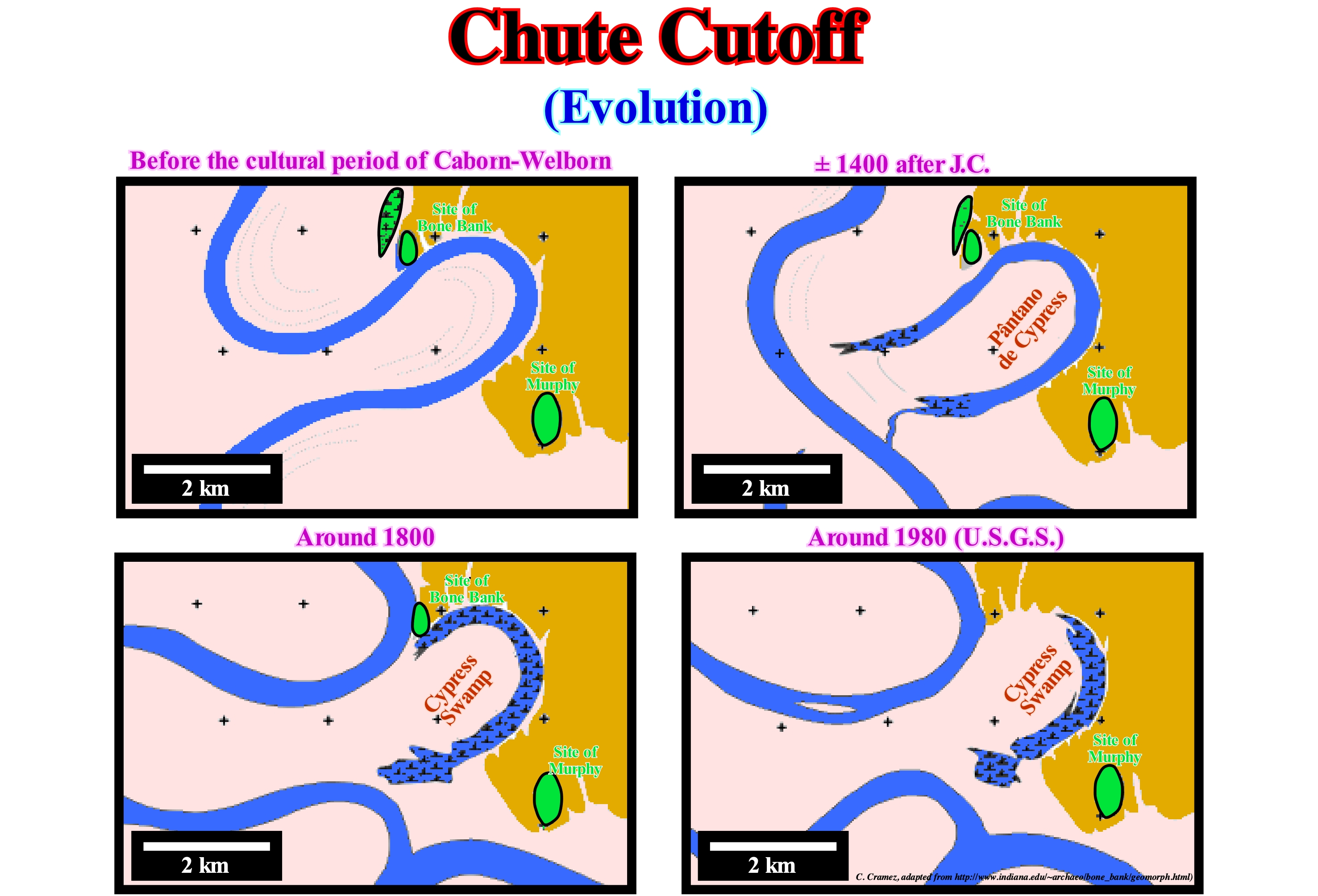
These maps illustrate the morphological changes of the Bone Bank archaeological site area has undergone during the last millennium. At present, the oxbow lake (Cypress swamp), which is, mostly, filled by alluvium, is south and east of the site. Before the Caborn-Welborn civilization, about 1,700 years ago, the Wabash River ran along, more or less, tight meanders. However, by the beginning of the fifteenth century, the river cut the narrow chute cutoff by a shortcut individualizing a oxbow lake (Cypress Swamp lake). Today, as illustrated in the USGS map, the morphology is quite different from that of 1807. In reality, for about 200 years, a meander has continuously destroyed the western margin of the archaeological site. The formation of point bars and the filling, by clay sediments, of the oxbow lakes (clay plugs) are not associated, at least directly, with relative sea level changes, i.e., relative sea level rises which increase the space available for sediment. Similarly, the erosion of the meander banks (concave portion of the meander) is not induced by a relative sea level fall. In this type of sedimentary environment, deposition and erosion are local phenomena, directly, associated with the flow velocity of the stream, which is higher in the external part (where there is erosion) than in the internal part where there is deposition (point bar). Thus, the terminations of the bedding planes (onlaps) observed in the point bar and the clay plugs (which are often well visible in seismic lines, particularly in 3D lines) do not define erosional surfaces, i.e., unconformities induced by significant relative sea level falls. In other words, these surfaces (stratigraphic or seismic) do not limit stratigraphic cycles. The influence of relative sea level changes is here insignificant.
Necrophagous....................................................................................................................................................................................................Nécrophage
Necrófago / Necrófago / Nécrophage, Aas / 嗜尸 / Трупоядный / Necrofagi /
Organism that eats dead or decaying flesh.
See: « Animalia »
&
« Benthos »
&
« Meroplankton »
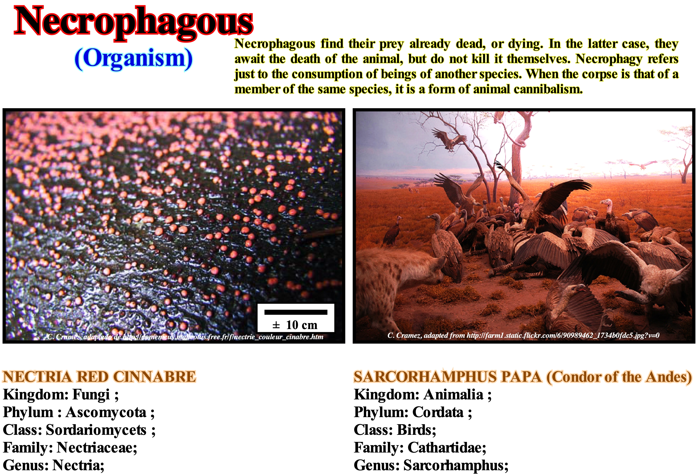
A necrophage or detritivore is an animal that feeds on organic remains (plants and dead animals), recycling them and returning them to the food chain to be reused by other living organisms. A food chain or web (or trophic as many authors call it) is a sequence of living beings/populations that feed on each other. The most common examples of necrophage are buzzards, vultures, hyenas and various species of beetles and flies. This type of feeding is a form of saprophagy, which in the case of plants is called saprophyty. Saprophyte, saprotrophic or saprotroph is the name given in biology to organisms, including plants, fungi and other beings, which feed by absorbing organic substances, usually, from decomposing organic matter. The saprophytic plants do not have the capacity to make photosynthesis. With the same etymology the term saprovores is also used for animals. Other general terms for this type of living beings are saprobios or saprobionts. Detritivorous are of fundamental importance because they promote the degradation of organic matter, facilitating the work of fungi and bacteria (http://pt.wikipedia.org/wiki/ Detrit% C3% ADvoro). In mythology, the necrophagous are beings that feed on human cadavers that often kill their victims, who never realize that they are in front of a scavenger as they change their form. They are part of many legends from Europe and the Middle East. Necrophagous have their place in Western folklore. It was in the legends of the Arab Islamic world that they first appeared (they belonged to a rebellious race of evil spirits). According to these legends, they dwell in the deserts, hide in caves, wander in the woods, and err in the places where humans died. The scavengers were always feared throughout North Africa, the Middle East and India. (http://en.wikipedia.org/wiki/Necrófago_(mitolog%C3%A).
Negative Coastal Aggradation (Downward shift of coastal onlap)................Aggradation côtière négative
Agradação costeira negativa / Agradación costera negativa / Küsten Verlandung / 负海岸沉积 / Прибрежные аккумулятивные отрицательные / Aggradazione costiera negativa /
Seaward and downward shifting of the coast onlaps. Such displacement, which is induced by a relative sea level fall, may bring the coastal onlaps lower than the depositional coastal break or lower than the basin edge. Only in the second case is the continental shelf and upper part of the continental slope exhumed (lowstand geological conditions). In lowstand geological conditions, when the basin has no shelf, i.e., during the 2nd stage of development of the highstand prograding wedge (LPW), the depositional coastal break and the continental edge are, more or less, coincident. In this case, the continental edge is, also, the basin edge. When coastal aggradation is negative, in general, an erosional surface is formed is to say, an unconformity that limits two stratigraphic cycles. During the formation of a n unconformity there is no deposition, except that of the turbidite systems in the deep part of the basin. In the available space curve of a cycle-sequence (curve of relative sea level changes), the segments during which the lowstand prograding wedge (LPW) and the transgressive interval (Ti) are deposited has the 1st and 2nd derivative are positive (the function is increasing and has a concave geometry or, in other words, the rate of rise of relative sea level is in acceleration). The segment during which the highstand prograding wedge (HPW) is deposited has the 1st derivative positive, but the 2nd derivative is negative (the function is increasing and has a convex geometry, which means that the rate of rise of the level of the sea is in deceleration). The deposition occurs during the period of relative sea level stability following each of the eustatic paracycles.
See: « Aggradation »
&
« Unconformity »
&
« Depositional Surface »
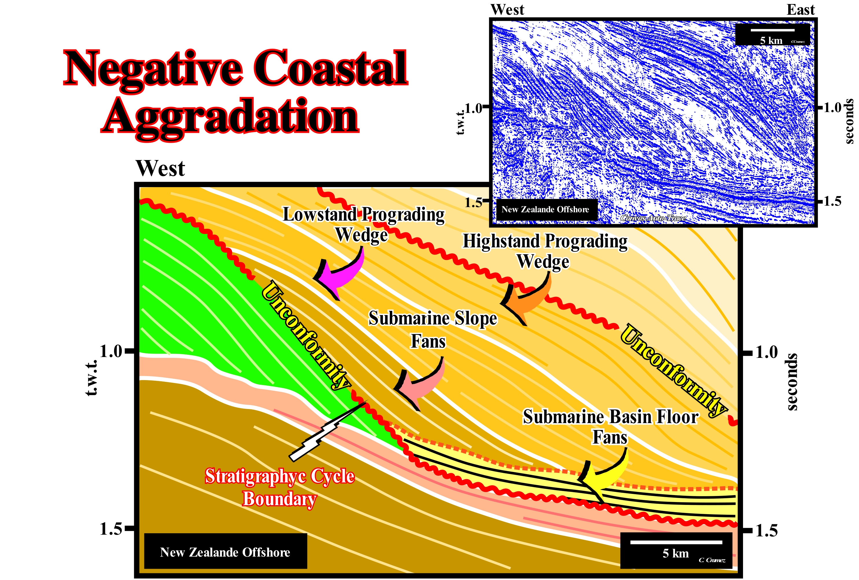
As illustrated on this tentative geologically interpretation a Canvas auto-trace of a detail of a New Zealand offshore seismic line, in the progradational sedimentary intervals (the geometry of the two lower intervals is mainly aggradational), the downlaps are predominant. These terminations are associated with decelerating relative sea-level rises, i.e., increasingly smaller marine ingressions that induce increasingly important sedimentary regressions, since the terrigeneous influx increases. The dipping seaward reflections end against reflections or subhorizontal seismic surfaces by downlaps. Within each stratigraphic cycle (this tentative interpretation is in part made in sequence-cycles, but is not calibrated, which means that the age of unconformities is not known with precision), a relative sea level fall induced a basinward (negative continental encroachment) and downward (negative aggradation) displacement of the coastal onlaps. When a geoscientist speaks of a relative sea-level rise or fall, he/she is not referring to single events but to a series of marine ingressions with no relative sea-level falls between them in the first case, or to a series of relative sea level falls (marine regressions) with no rises between them in the second. A negative coastal aggradation underlines an unconformity, i.e., an erosional surface on the platform and on the top of the continental slope that were exhumed (visible in the west continuation of this line). Such an exhumation favoured the deposition of the turbidite systems in the deep parts of the basin, since the sedimentary influx increases, significantly, and the available space for the sediments decreases. The deep deposits, in particular, the submarine basin floor fans (SBFF), are, easily, recognized in the eastern sector of this tentative, below the downlap surface of the progradational intervals (low and highstand prograding wedges). Since the relative sea level began to rise (beginning of lowstand prograding wedge) the erosional surface is, gradually, fossilized by the onlaps of the lowstand prograding wedge (LPW). The intervals considered (prograding wedges and submarine fans) do not belong, certainly, to a single sequence-cycle but, probably, to an overlap of incomplete sequence-cycles, which form a stratigraphic cycle of lower hierarchy (continental encroachment subcycle) deposited during a second-order eustatic cycle. Theoretically, if the age difference between the two unconformities (or their correlative deep water paraconformities), which separate the seismic intervals considered, is greater than 3-5 My, these intervals can not be interpreted as sequence-cycles, but as continental encroachment subcycles (if the difference is less than 50 My). A sequence-cycle is associated with a 3rd order eustatic cycle (time-duration between 0.5 and 3-5 My), whereas a continental encroachment sub-cycle, which is composed of several sequence-cycles, is associated with an eustatic cycle of 2nd order (time-duration between 3-5 and 50 My). Within a second-order eustatic cycle a certain number of 3rd order eustatic cycles can be recognized. A continental encroachment cycle is induced by a 1st order eustatic cycle (time-duration greater than 50 My) and composed of several continental encroachment sub-cycles. Taking into account the hierarchy of stratigraphic cycles and the order of eustatic cycles (the hierarchy of stratigraphic cycles is opposite to the order of eustatic cycles), at the level of a sequence-cycle (3rd order eustatic cycle), variations in the level of the relative importance are paramount. At the level of a continental encroachment cycle (1st order eustatic cycle), it is the absolute (eustatic) sea level changes that are responsible for the cyclicity**. In a sequence-cycle or continental encroachment subcycle, the available space for the sediments is, basically, given by the relative sea level changes. In general, when a geoscientist speaks of sea level she/he is, in general, referring to relative sea level. To avoid possible confusion, a geoscientist should always specify what sea level it is. In association with an absolute (eustatic) sea level, sedimentary transgressions are deposited and sedimentary regressions are deposited in association with an absolute sea level fall, which is not the case when it comes to relative sea level rises and falls.
(*) Local sea level referenced to any point on the Earth's surface, such as the base of the sediments (top of the continental crust) or sea floor. The relative sea level is the result of the combined action of absolute (eustatic) sea level, which is global and referenced to the Earth's centre, and tectonics (subsidence or uplift of the sea floor).
(**) The absolute (eustatic) sea level is a function of: (i) Tectono-Eustasy (variation of the volume of ocean basins in association with oceanic expansion following the break-up of the supercontinents) ; (ii) Glacio-Eustasy (variation of water volume of the oceans as a function of the quantity of ice, assuming that the amount of water in all its forms is constant since the Earth's formation, there are about 4.5 Ga) ; (iii) Geoidal-Eustasy (distribution of ocean water caused by variations in the terrestrial gravity field, and (iv) Steric rise in sea level or thermal expansion of the oceans.
Negative Encroachment..........................................................................................Empiétement continental négatif
Invasão Continental Negativa / Invasión continental negativa / Übergriff Continental negativ / 负水侵 / Отрицательное континентальное затопление / Invasione continentale negativa /
When the coastal onlaps move seaward and downward. In general, there is no deposition except in deep turbidite depositional systems.
See: «Coastal Onlap Curve »
Negative Reflection...............................................................................................................................................................Réflexion négative
Reflexão negativa / Reflexión negativa (sísmica) / Negative Reflexion (seismische) / 负反射(地) / Отрицательное отражение / Riflessione negativa (sismica) /
When the acoustic impedance of the upper interface interval, which defines the reflection, is greater than that of the lower interval (example: limestone/clay, or clay/sand).
See: « Reflection Coefficient »
&
« Acoustical Impedance »
&
« Reflection Seismic »
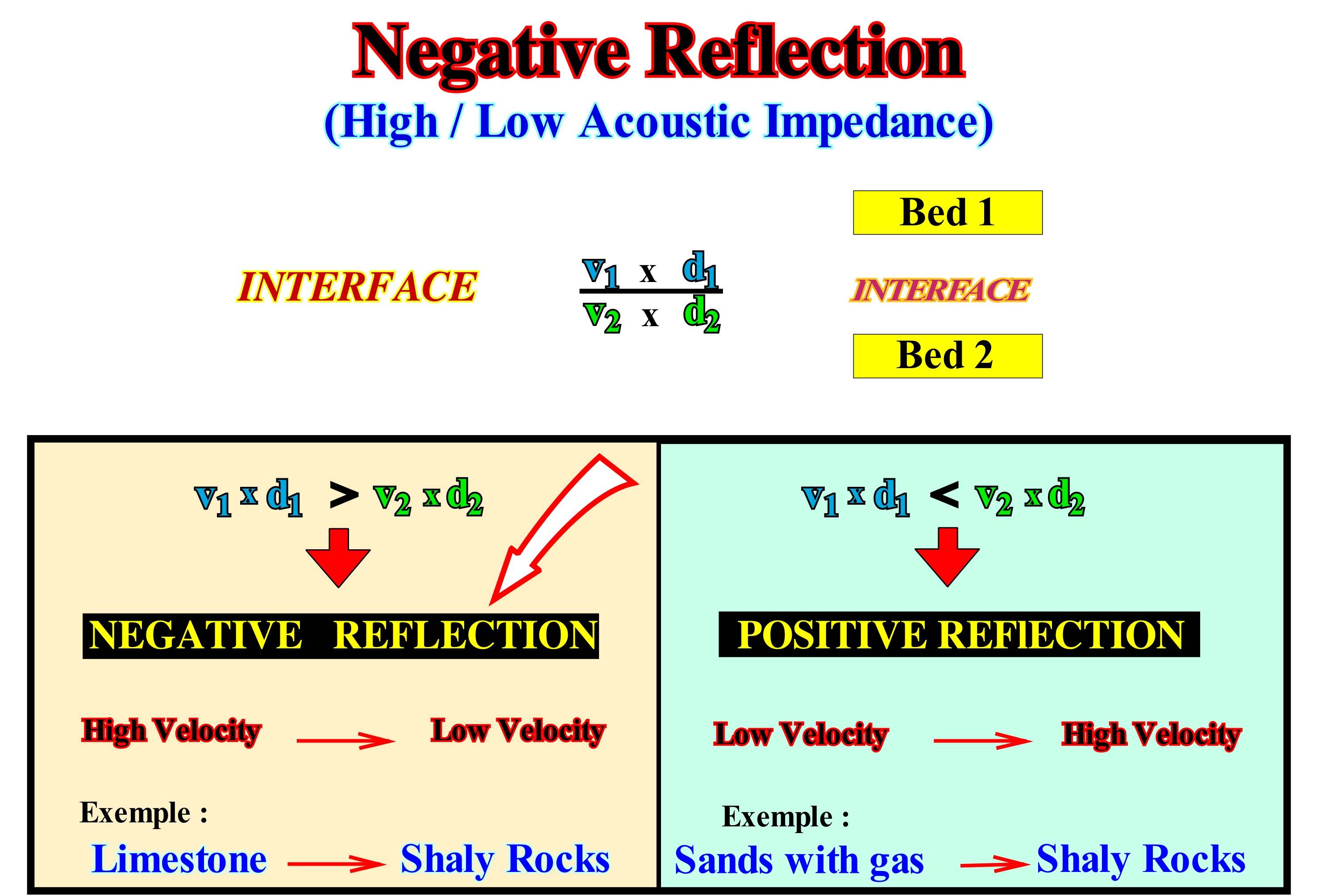
A seismic reflection is induced by an acoustic impedance contrast. The acoustic impedance of a given interval is the product of the velocity of the seismic waves, through the interval, by the density of the interval. A negative reflection occurs when the acoustic impedance of the upper interval is greater than that of the lower interval. An interface between a limestone interval and a shale interval or between a shale and sandy interval creates a negative reflection. In the SEG convention, i.e., for the European Geophysical Society, in a seismic line, a negative reflection is represented by a deflection to the left of the baseline of the seismic trace. It is coloured white (negative polarity). In contrast, when the acoustic impedance of the lower interval is greater than that of the upper interval, the associated seismic reflection is positive (as, for example, shale/limestone, etc.). According to the same convention, a positive reflection materializes by a deflection of the seismic trace to the right and the space between the trace and the baseline is coloured in black. Most geoscientists have a natural tendency to follow positive reflections (black to right), especially, when they have good continuity. In a sequential interpretation, when done in stratigraphic cycles and, if possible, in sequence-cycles, geoscientists are, often, obliged to jump from negative to positive reflection or vice versa in order to define the limits of stratigraphic cycles. A sequential interpretation is based on the identification and picking of the unconformities (erosional surfaces), which limit the different stratigraphic cycles. Even when unconformities are not tectonically enhanced (angular unconformities), the contrast of acoustic impedance between the sediments below and above the unconformity changes along the erosional surface that underlines it. To pick an unconformity, the geoscientist is, sometimes, forced to jump from a crest (black to right, positive reflection) to a trough (white to the left, negative reflection) or vice versa. It is said in the oil industry that picking an unconformity is for seniors and not for juniors.
Nekton...........................................................................................................................................................................................................................................................Necton
Nécton / Nécton / Nekton / 游泳动物 / Нектóн (совокупность свободно плавающих животных) / Necton /
Set of organisms of a water-body (ocean or lake) able to move (swim), independently, of the currents.
Se: « Plankton »
&
« Infauna »
&
« Facies »
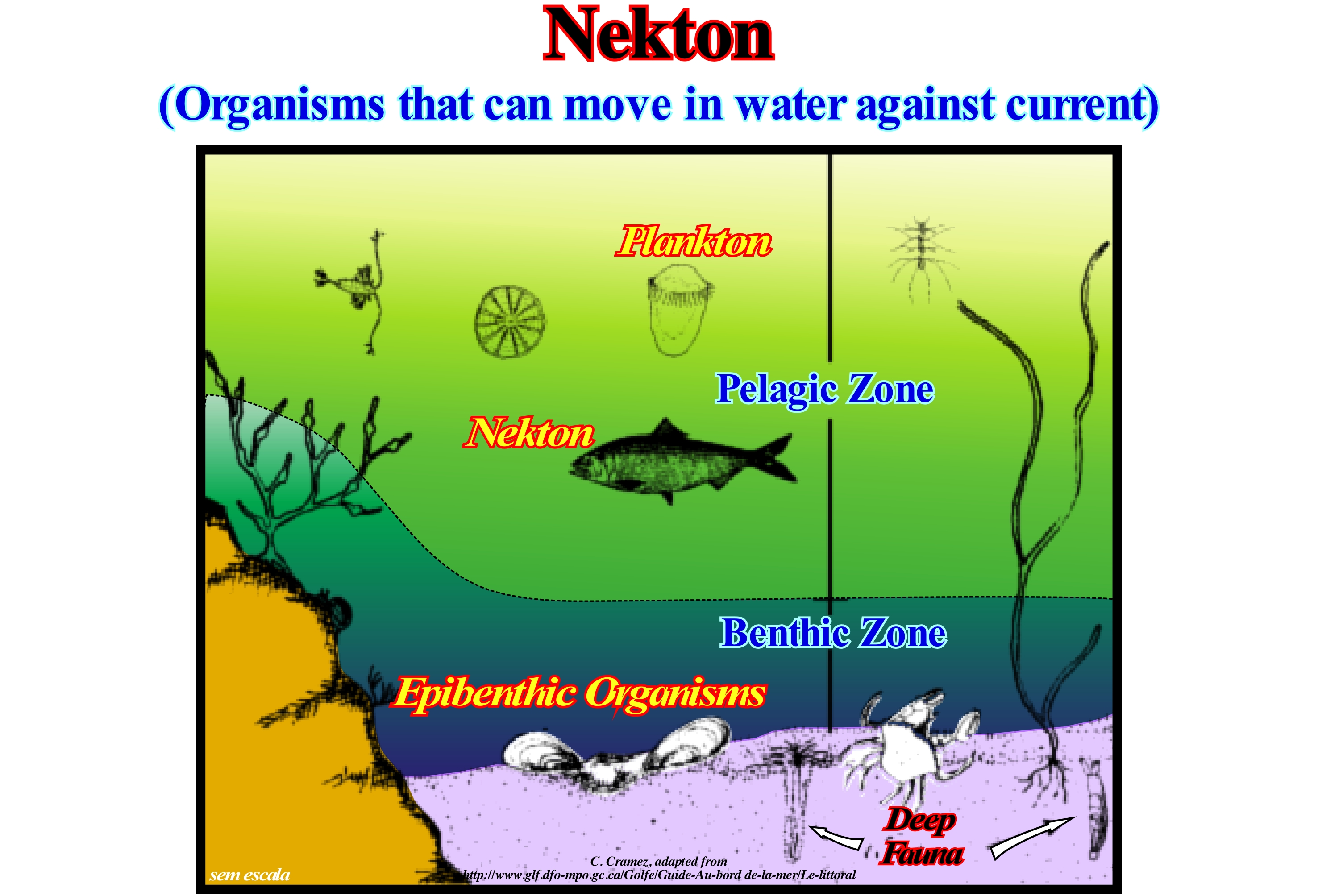
Nekton contrasts with plankton, which is the set of organisms, which floats and drifts, passively, in water-bodies, such as algae, bacteria, eggs and larvae of marine organisms, protozoa and other small predators. Most, but not all, of the planktonic organisms are very small (the largest diameter is less than 1 cm), while the length of the organisms forming the nekton (nektonic organisms) ranges from a few centimeters to 30 meters. One of the characteristics of the nekton is the possibility that organisms, which form it, have to move quickly. Another characteristic is its manoeuvrability, whether in rectilinear or angular acceleration. They start, stop and turn with great ease. The size and velocity of displacement of plankton and nekton means that while plankton takes water as a viscous medium, often with reversible flows, the nekton is dominated by inertia. The oceanic nekton consists of a large variety of bony fish, sharks, rays, and in smaller numbers, mammals and reptiles. The only invertebrates that can be considered as nekton are the cephalopod mollusc. Fish that spend their entire life in the epipelagic zone (oceanic area where sunlight enters in sufficient quantity for photosynthesis to be possible) are holoepipelagic. Holoepipelagic species include white shark, spiny sea bream, yellow-fin tuna, striped marlin, swordfish, sunfish (fish of the molidae family), etc. The second group of oceanic fish is called meroepipelagic. The fish in this group spend only part of their life in the epipelagic zone. This group is more varied and includes fish, which spend adult life in the epipelagic zone, but lay the eggs near the shore (herring, whale shark, dolphin, etc.) or in fresh water, such as salmon. Another component of oceanic nekton is marine mammals such as whales, seals and sea lions (carnivores), etc. Among the marine mammals that live in the coastal waters, manatees, dugongs, sea otters, etc. can be mentioned.
Neogene Stratigraphic Signature...................................................Signature stratigraphique (Néogène)
Assinatura Estratigráfica do Néogeno / Firma estratigráfica (Neógeno) / Stratigraphische Unterschrift (Neogen) / 地层签名(第三纪 ) / Неогеновая стратиграфическая аномалия / Signature stratigrafica (Neogene) /
Neogene stratigraphic signature is characterized by: (i) Continentward thickening during the Early Oligocene ; (ii) Shifting of coastal onlaps to the deep parts of the basins during the Late Oligocene ; (iii) Maximum flooding during the Early Miocene (24.8 Ma) ; (iv) End of a predominant aggradation, during the Early Miocene (Aquitanian, 22.0 Ma) and deposition of large lowstand prograding wedges ; (v) End of Early Miocene (Burdigalian 21.0 Ma) predominant aggradation and deposition of lowstand prograding wedges ; (vi) Flood, during the Middle Miocene (Langhian and Lower Serravaliian, 15 Ma/6 Ma) ; (vii) Significant progradation during Middle Miocene (Serravalian, 15 Ma/10.5 Ma) ; (viii) Substantial downward and downward displacement of lowstand prograding wedges (10.5 Ma) ; (ix) Ending of Late Miocene agradation and deposition of lowstand prograding wedges (10.5 Ma/5.0 Ma) ; (x) Flooding during the Early Pliocene (5.0 Ma) ; (xi) Aggradation during the Early Pliocene and Pleistocene with many lowstand deposits (5.0/1.6 Ma) and finally (xii) Deposition of high frequency stratigraphic cycles during Late Pleistocene.
See: « Stratigraphic Cycle »
&
« Sequential Stratigraphy »
&
« Signature in Stratigraphic Record »
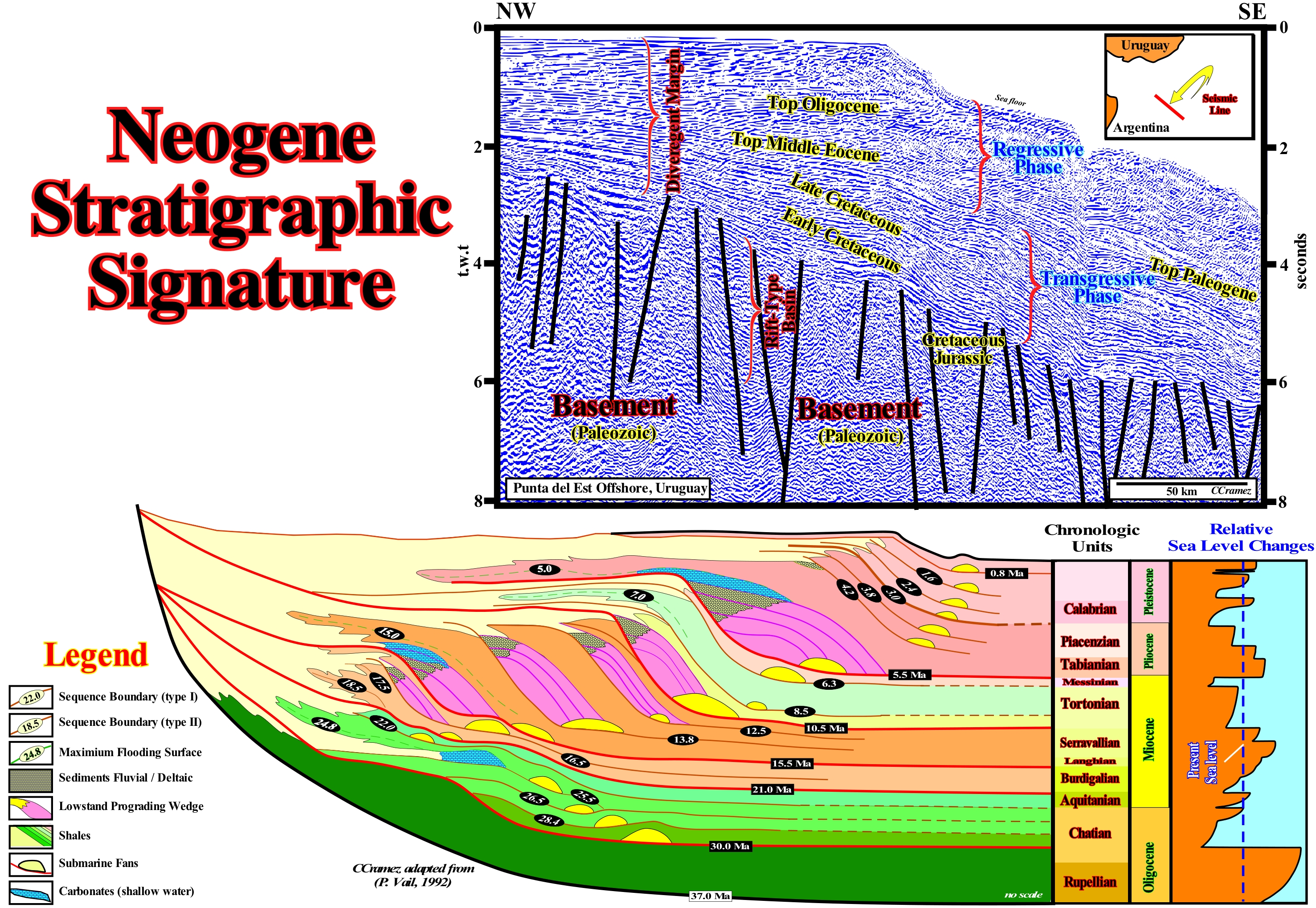
The diagram represents the stratigraphic signature of the Neogene, as proposed by Peter Vail and his students in 1992. Three major transgressive episodes were recognized in association with the downlap surfaces: DS. 24.8 Ma ; DS. 16/15 Ma and DS. 5.0 Ma. The seaward displacement of sediments (sedimentary regressions) and to the continentward (sedimentary transgressions, i.e., the retrogradational set of smaller and smaller sedimentary regressions induced by increasingly important marine ingressions, that is, by relative sea level rises in acceleration (as shown in the diagram of the stratigraphic signature) are: (i) Seaward (regressive episode), between 30.0 Ma and 25 , 5 Ma ; (ii) Continentward (transgressive episode), between 25.5 Ma and 24.8 Ma ; (iii) Seaward (regressive episode), between 24.8 Ma and 15.5 Ma ; (iv) Continentward (transgressive episode), between 15.5 Ma and 15.0 Ma ; (v) Seaward (regressive episode), between 15.0 Ma and 10.5 Ma ; Continentward (transgressive episode), between 10.5 Ma and 5.0 Ma and (vii) Seaward (episode regressive), between 5.0 Ma and 0.8 Ma. The alternation of the internal configurations of these stratigraphic intervals is very visible in the seismic lines. This is particularly true on the divergent margins, as illustrated on the tentative geological interpretation of a Canvas auto-trace of an Uruguay offshore seismic line. The recognition of such alternation, sometimes, allows to date. a priori, stratigraphic intervals, which are, usually, sequence-cycles (when the age difference of the unconformities that limit them is between 0.5 My and 3-5 My) or continental encroachment subcycles (when the age difference between the unconformties that limit them is between 3-5 My and 50 My). In association with relative sea level falls (combination of absolute sea level and subsidence or uplift of the sea floor induced by tectonics), which induced the unconformities SB. 5.5 Ma, SB. 10.5 Ma, SB. 12.5 Ma, SB. 13.8 Ma, SB. 15.5 Ma and SB. 16.5 Ma, and their correlative deep-water paraconformities, were deposited in the deep parts of the basins, submarine fans (colored in yellow). These turbidite submarine fans (set of submarine basin floor fans, SBFF, and slope fans, SSF) are, generally, fossilized, i.e., covered by thick lowstand prograding wedges (LPW) (coloured in violet). The unconformity SB. 30 Ma, seems to have been induced by a great fall of the absolute (eustatic) sea level (referenced to the Earth's centre), during Oligocene. This falling of the absolute sea level, which occurred, more or less, between the Rupelian and the Chattian was, for a large number of geoscientists, probably, induced by the formation of the Antarctic ice sheet*, which in some places has, currently, a thickness of about 4,000 meters, above a rocky continent. The geometry of the sediments of the Upper Oligocene (above the limit of sequence-cycle SB. 30 Ma) and the Lower Miocene (Aquitanian/Burdigalian) is, mainly, retrogradational**. It contrasts with the progradational geometry of the later sedimentary intervals, in which lowstand geological conditions are predominant. As illustrated by the relative sea level changes, it can be said that after the great eustatic sea level fall, during the Oligocene, the absolute (eustatic) sea level, as a whole, has risen till the Burdigalian and then fall until the beginning of the Pliocene (SB. 5.5 Ma). A further absolute sea level rise occurred in the Lower Pliocene, and then it fall during the Pleistocene ice ages. After the glaciations, the melting induced an absolute sea level rise of about 120/130 meters. The melting of an ice mass only produces a sea level rise when its substrate is rocky. The melting of a glacial platform (ice sea), unlike that of an inlandsis produces a absolute sea level fall, since the ice is less dense than the water.
(*) Inlandsis is a Scandinavian term meaning "ice in the middle of the Earth" and therefore should not be confused with a ice sea or ice platform. The melting of an inlandsis, as well as the melting of a glacier (in a less significant way), originates an absolute sea level rise (eustatic rise), while the melting of a ice sea or ice platform causes an eustatic fall.
(**) In sequential stratigraphy, the term retrogradational, as for example in retrogradational sedimentary interval, does not have the same meaning as in ordinary language (backward). It simply means that, on the whole, the sedimentary interval is thickening continentward, i.e., in the opposite direction to the thickening of a progradational interval.
Neritic....................................................................................................................................................................................................................................................Néritique
Nerítico / Nerítico / Neritischen / 浅海 / Неритический / Neritico /
Marine environment characterized by a water-depth between 0 and 200 meters. Three subenvironments can be distinguished: (i) Inner Neritic, with a water- depth between 0 and 30 m ; (ii) Middle Neritic, with a water-depth between 30 and 100 m and (iii) Outer Neritic, with a water-depth between 100 and 200 m.
See: « Bathyal »
&
« Depositional Environment »
&
« Shelfal Accommodation »
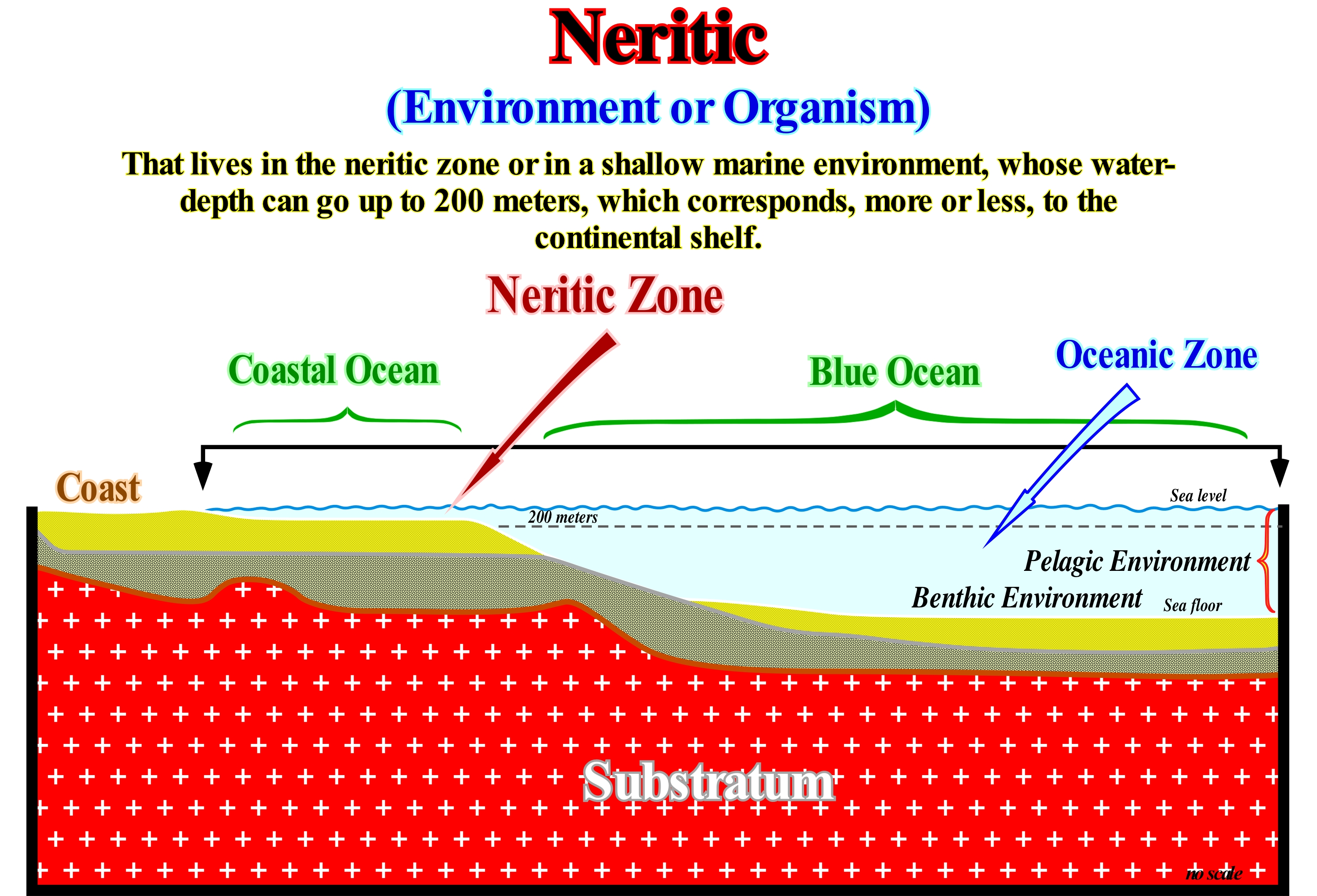
The neritic zone comprises the first 200 meters of ocean water. It encompasses the coastal zone (near the coastline) and the continental shelf (up to the continental edge). It is in this zone that most of life is made from photosynthesis (life that uses solar energy to convert carbon dioxide, CO2, into water and food), such as phytoplankton and floating seaweeds of the genus sargassum (fucal algae). Zooplankton, which is formed by floating creatures (from microscopic diatoms to small fish, shrimp, etc.) also lives in this area. Many species of whales, such as the giant whale, etc., feed almost entirely on zooplankton. These whales force the sea water through the bone material that formed in place of the teeth, to filter out the small marine organisms. The largest of all fish, the white shark, lives alone outside the plankton. The ocean is a vast domain. It covers more than 71% of the Earth's surface. Of these 71%, about 65% are considered as the blue ocean (open ocean). The other 35% form the coastal ocean, which covers the continental shelves (when they exist). The world of animals, plants, and birds is, relatively, flat, i.e., it never develops far above or far below the Earth's surface, which, of course, is not the case in the oceans. The oceans have an average depth of more than 3.3 km and contain life almost everywhere in the same depths. Life in the oceans is divided into two categories: (i) Benthic (on the sea floor) and (ii) Pelagic (the waters of the ocean). Function of the depth, the pelagic environment can also be divided into: (a) Epipelagic or Euphotic zone (enough O2, few nutrients, plants) ; (b) Mesopelagic or Dysphotic Zone (little O2, increase of nutrients, animals, bacteria) and (iii) Bathypelagic Zone or Abyssopelagic Zone (O2 increases, nutrients decrease, contribution of polar waters).
Névé (Firn, snow field)............................................................................................................................................................................................................................Névé
Nevado / Nevado / Firnschnee / 粒雪 / Фирновый снег / Ghiacciaio, Nevato /
Glacial environment encompassing the volume of snow above the snowline.
See : « Firn »
&
« Glacier »
&
« Snowline »
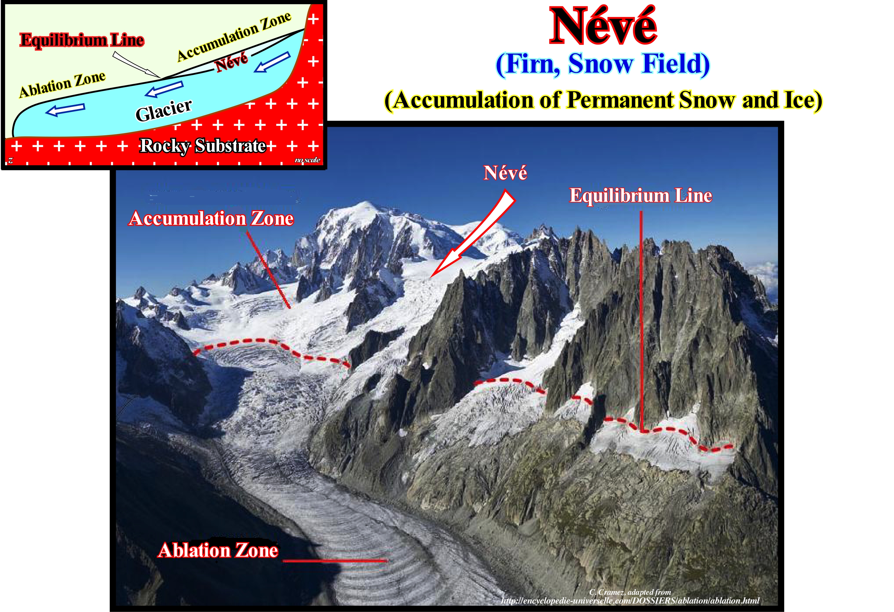
In a glacier, the névé is a type of snow of the past winters that recrystallized in a substance more dense than the snow. Some geoscientists also distinguish the névé, properly speaking, of the compacted névé, which is even harder and denser. Either way, the névé is an intermediate ice between the snow and ice glacier (crystalline ice, with crystals interconnected, compacted and with a density of 0.83 - 0.93 km3). The névé, as shown above (diagram on the left), is upstream of the equilibrium line, which separates the ablation zone from the accumulation zone, has a moist sugar appearance, but with a hardness which makes it extremely resistant. The névé is, often, found under the cool snow at the top of the glacier. The snowflakes are compressed under the weight of the overlying snow packets. The crystals near the melting point are semi-liquid and smooth, allowing them to slide against each other and fill the space between them, which increases, significantly, the density. In the summer months, crystalline metamorphoses can occur, rapidly, due to the percolation of the water between the crystals and, at the end of summer, the result is always the formation of névé, whose lower limit corresponds to the snow line that is, more or less, coincident with the equilibrium line. When the crystals come in contact, they bind to each other, and compress the air between them forcing it to move to the surface or insulating it in bubbles that remain trapped in the ice. The formation of these air bubbles, which have been used to determine the CO2 content of the atmosphere over the last few thousand years, is much more complex than many people think. Some bubbles may, sometimes, take 5,000 years to close, which means that the air they contain is a sample of the atmosphere for 5,000 years. Contrary to what certain ecologists say, it is impossible to say that the analysis of air bubbles of a given glacier sounding sample can correctly determine the CO2 content of the atmosphere, for example 500 years ago. The ice age has nothing to do with the age of the air bubble closure*, since up to the time of closure (1,000 - 5,000 years) the air has always been in contact with the atmosphere.
(*) The values determined in the closed bubbles do not correspond to the closing time of the bubbles. They correspond to the aggregation of all CO2 values during the deposition of snow. Finding an aggregated value is not simple. It is better to speak in terms of average age and maximum age corresponding to the closure of the bubbles. It is quite clear that we should avoid talking about gas content at a certain age, but rather an average gas content in a given period of time (with an associated uncertainty of several millennia). In addition, the greater the depth of an ice core, the greater the ice compaction, i.e., that a core of ± 50 cm in length (minimum required to measure gas concentrations) corresponds to about a millennium. In other words, there is a smoothing in the snow age and also in the sampling of the bubbles. The depth of the bubble closure changes as a function of the rate of snow accumulation and temperature. The annual accumulation rate also changes a lot. It is ± 2 cm per year, in Vostok, and is ± 50 cm / year on the continent shores. In the Vostok area, there seems to be agreement between snow accumulation rates and depth of bubble closure, but there is a strong disagreement over the age of bubble closure.
Nife....................................................................................................................................................................................................................................................................................Nife
Nife / Nife / Nife (Nickel - Eisen) / 镍铁 / Центральное ядро земли (из никеля и железа) / Nife (Nickel - Ferro) /
Abbreviation for the mixture of nickel (Ni) and iron (Fe) that characterizes the composition of the Earth's core, in which a liquid outer part and a solid inner part can be distinguished.
See: « Sial »
&
« Sima »
&
« Crust »
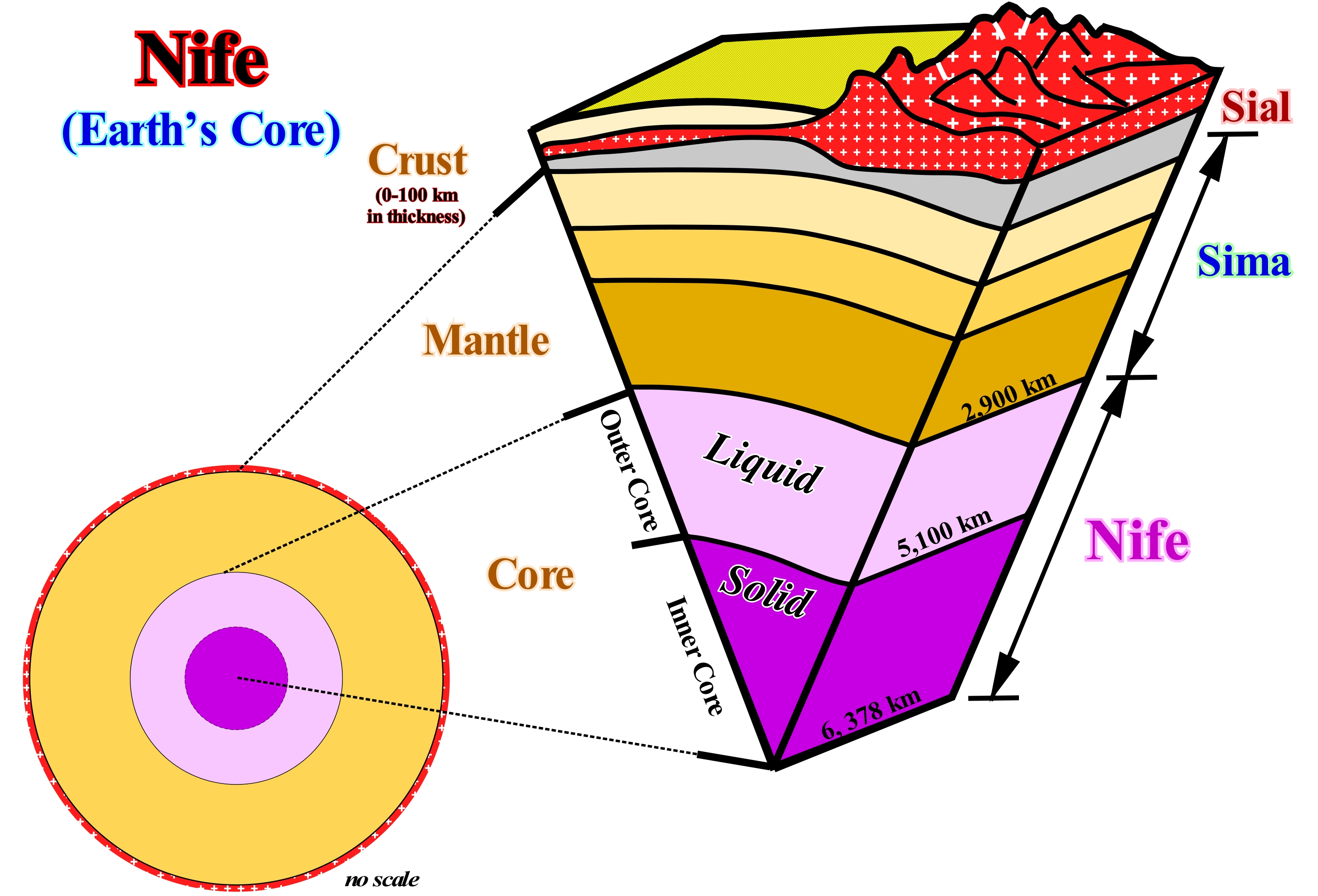
The fragile outer layer of the Earth is the crust that corresponds to the shell of the lithosphere. The crust can be divided into: (i) Continental crust and (ii) Oceanic Crust. The upper layer of the crust is the continental crust, which is less dense and consists, mainly, of silica and aluminum. That is why it is also called sial (SI- Silicium, AL-Aluminum). The average density of the sial is about 2,700-2,800 kg/m3. A large majority of the geoscientists refer to the rocks that form the sial as "granite rocks", since granite is, undoubtedly, the predominant rock. The oceanic crust is denser and, essentially, basaltic, which means that, in reality, the sial is made up of a great variety of rocks. Underneath the sial is a thick layer, called SIMA. It is formed, mainly, by silica and magnesium (with large amounts of iron). The sima is denser than the sial. The average density of the sima varies between 2,800 and 3,300 kg/m3, in the upper part, and in the lower middle part, between 3,300 and 5,600 kg/m3. The sima extends to 2,900 km of depth, that is, to the upper limit of the Earth's core, which is also called NIFE, since nickel and iron are its main components. In summary: from the point of view of chemical composition, the Earth can be divided into three layers: (i) SIAL, a thin, fragile, superficial layer, mainly composed of silica and aluminum ; (ii) SIMA, intermediate layer, with a thickness of about 2,850 km, ductile, dense, mainly composed of silica and magnesium and (iii) NIFE, internal layer equivalent to the Earth's core. The nife has a thickness about 3,500 km and consists mainly of nickel and iron. The density of the nife exceeds 5,600 kg/m3. The outer part of the nife is liquid, since the S waves (secondary waves that arrive late in relation to the P waves, since they travel more slowly) do not penetrate it. The outer part of the nife seems to be solid, since it is crossed by the S waves. This chemical division of the Earth should not be confused with the rheological division, in which several layers can be considered: (a) Lithosphere; (b) Astenosphere; (c) Mesosphere and (iv) Core.
Nimbostratus.......................................................................................................................................................................................................Nimbostratus
Nimbostrato / Nimbostrato / Nimbostratus / 雨层云 / Слоисто-дождевые облака / Nembostrato /
Low stratiform cloud (between the Earth' surface and 3,000 meters of altitude), without particular form and that, generally, produces rain. The average thickness of nimbostratus is about 2,000 meters.
See: « Cloud »
&
« Atmosphere »
&
« Climate »
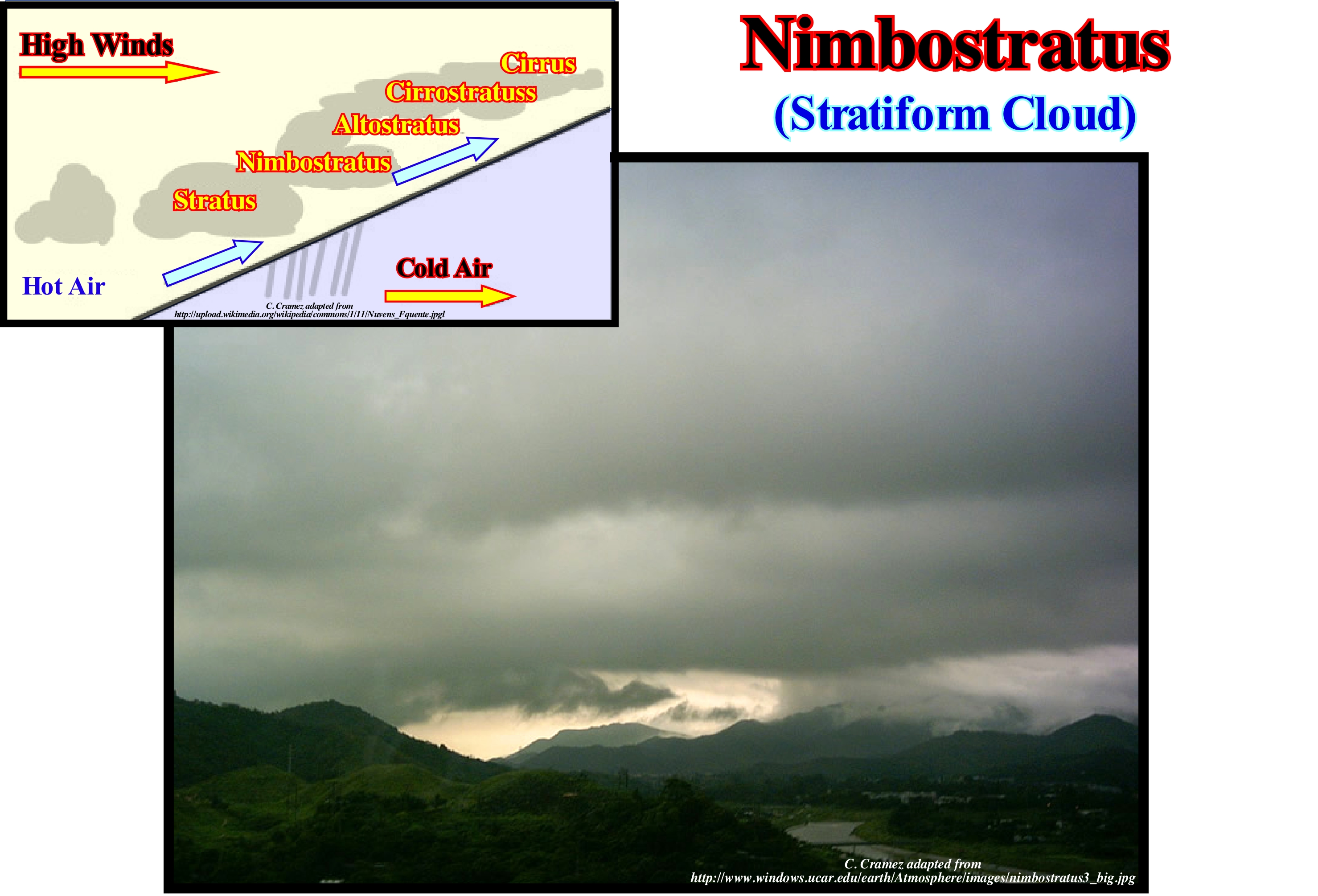
Nimbostratus are clouds with amorphous aspect, diffuse base and low, very thick, dark or grey Nimbostratus produce intermittent and, more or less, intense precipitation. The nimbostratus are dense clouds in the form of grey layers, usually, dark and totally obscuring the sun, accompanied by precipitation (nimbus in Latin means "rain"). Nimbostratus are formed in air masses with some instability, when the humidity is moderate or high and the temperature is relatively high, and are, usually, associated with hot or occluded fronts. Evaporation of rain-water, usually, results in low visibility, and a lower layer of clouds or fog may form beneath the nimbostratus if the air becomes saturated. Do not forget that a cloud is a visible set of tiny particles of liquid water or ice, or both at the same time, suspended in the atmosphere. This assembly may also contain particles of larger liquid or ice water, and particles from, for example, industrial vapour, smoke or dust. The clouds are the humidity of condensed air. They consist of droplets of water and/or ice crystals. As regards its aspects, clouds can be subdivided into: (i) Stratiforms ; (ii) Cumuliforms and (iii) Cirriforms. The stratiforms developed horizontally, covering a large area, with little thickness giving a light and continuous precipitation. The cumuliforms developed vertically, of great extension, isolated giving. The cirriforms are horizontal, fibrous, fragile-looking clouds of development that occupy the high atmospheres and which are formed by tiny ice crystals (these clouds do not give rise to precipitation, but are precipitation). The main types of clouds, which most meteorologists consider are: (a) Cirrus; (b) Cirrocumulus; (c) Cirrostratus ; (d) Altostratus; (e) Altocumulus ; (f) Stratus ; (g) Stratocumulus; (h) Nimbostratus ; (i) Cumulus ; (j) Cumulonimbus, etc. According to https://scied.ucar.edu/imagecontent/cirrus-cloud, cirrus clouds are made of ice crystals and look like long, thin, wispy white streamers high in the sky. They are commonly known as "mare's tails" because they are shaped like the tail of a horse. Cirrus clouds are often seen during fair weather. But if they build up larger over time and are followed by cirrostratus clouds, there may be a warm front on the way. Cirrocumulus clouds are small rounded puffs that usually appear in long rows high in the sky. Cirrocumulus are usually white, but sometimes appear gray. They are the same size or smaller than the width of your littlest finger when you hold up your hand at arm's length. When these clouds cover a lot of the sky, they can look like the scales of a fish, which is it is called a "mackerel sky.” Cirrocumulus are common in winter and indicate fair, but cold, weather. Cirrostratus clouds are high, thin sheet-like thin clouds that usually cover the entire sky. The clouds are so thin that the Sun or moon can sometimes shine through and appear to have a halo as light hits the ice crystals and bends. The halo is the width of your hand held at arm's length. Cirrostratus clouds usually come 12 to 24 hours before a rain or snowstorm. Altostratus clouds are mid-level, gray or blue-gray clouds that usually covers the whole sky. The Sun or moon may shine through an altostratus cloud, but will appear watery or fuzzy. If you see altostratus clouds, a storm with continuous rain or snow might be on its way. Occasionally, rain falls from an altostratus cloud. If the rain hits the ground, then the cloud has become a nimbostratus. Stratus clouds are low and have a uniform gray in colour and can cover most or all of the sky. Stratus clouds can look like a fog that doesn't reach the ground. Light mist or drizzle is sometimes falling when stratus clouds are in the sky. Stratocumulus clouds are low, lumpy, and gray. Sometimes they line up in rows and other times they spread out. Only light rain (usually drizzle) falls from stratocumulus clouds. To distinguish between a stratocumulus and an altocumulus cloud, point your hand toward the cloud. If the cloud is about the size of your fist, then it is stratocumulus. Cumulus clouds have vertical growth. They are puffy white or light gray clouds that look like floating cotton balls. Cumulus clouds have sharp outlines and a flat base at a height of 1000m. They are generally about one kilometre wide which is about the size of your fist or larger when you hold up your hand at arm's length to look at the cloud. Cumulus clouds can be associated with fair or stormy weather. Watch for rain showers when the cloud’s tops look like cauliflower heads. The highest clouds in the atmosphere are cirrocumulus, cirrus and cirrostratus. Cumulonimbus clouds can also grow to be very high. Mid-level clouds include altocumulus ans altostratus. The lowest clouds in the atmosphere are stratus, cumulus and stratocumulus.
Nitrogen Cycle...............................................................................................................................................................................................Cycle de l'azote
Ciclo do azoto / Ciclo de Nitrógeno / Stickstoffkreislauf / 氮循环 / Цикл обмена азота / Ciclo dell'azoto /
Process by which nitrogen, in all its forms, circulates through the Earth, in the same way as water does (hydrological cycle). Most nitrogen reserves are found in the lower part of the first layer of the Earth's atmosphere, i.e., in the homosphere, which encompasses the troposphere, stratosphere and mesosphere and is characterized by having: (i) About 78-80% of nitrogen ; (ii) Plus or minus 20% oxygen ; (iii) 1% water vapour ; (iv) 0.9% argon and (v) 0.04 carbon dioxide. Neon, helium, krypton, hydrogen and ozone are present in the atmosphere in ppm (parts per million).
See: « Hydrologic Cycle »
&
« Rock Cycle »
&
« Atmosphere »
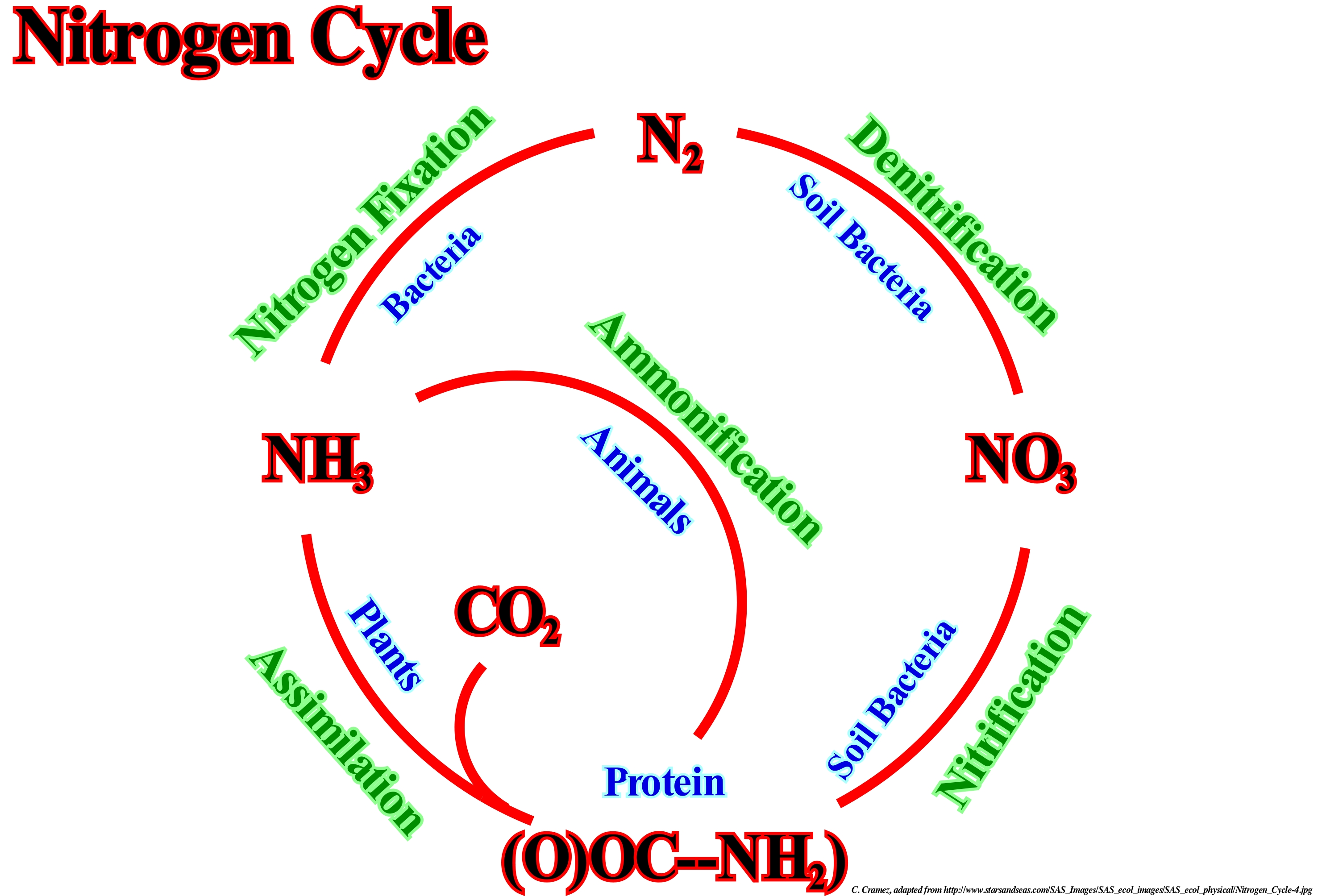
The whole life form requires nitrogen compounds (proteins and nucleic acids). The air has about 80% nitrogen (N2) and is the largest nitrogen reservoir. Most organisms can not use nitrogen directly. Plants use nitrogen by incorporating certain compounds, such as: (i) nitrate ions (NO3-) ; (ii) Ammonia (NH3) ; (iii) Urea (NH2)2CO, etc. The animals use the nitrogen compounds by eating the plants. In the biosphere, four processes participate in the nitrogen cycle: (a) Fixation ; (b) Denitrification* ; (c) Nitrification and (d) Assimilation. In fixation, three processes are responsible for the majority of nitrogen fixation in the biosphere: 1) Atmospheric Fixation by Light ; 2) Biological Fixation (microbes) and 3) Industrial Fixation. In the assimilation, the proteins made by the plants enter the food chains and their metabolism produces organic compounds of nitrogen that return to the environment, mainly, in the form of excretions and that under the action of certain micro-organisms produce ammonia. In nitrification**, the ammonia can be directly incorporated by the plants through the roots. However, much of the ammonia produced by decomposition is converted into nitrates, which is done in two steps: bacteria of the genus Nitrosomone oxidise NHO3 to NO2- and bacteria of the genus Nitrobacter oxidise nitrites (NO2-) to nitrates. The three preceding processes draw nitrogen from the atmosphere and incorporate it into ecosystems. Denitrification reduces nitrates into nitrogen (gas) which replaces nitrogen in the atmosphere. Bacteria are the major agents, since they use nitrates as an alternative to oxygen for their respiration.
(*) Chemical-biological process of formation of nitrite in the soil by the joint action of nitrifying chemosynthesizing bacteria, by the conversion of ammonia into nitrate, which occurs in two stages: (I) Nitrification, 2NH3 (ammonia) + 3O2 → 3O2 → 2H+ + 2NO-2 (nitrite) + 2H2O + energy and (ii) Nitrification, 2NO-2(nitrite) +O2 → 2NO-3 (nitrate) + energy.
(**) Biological oxidation of ammonia to nitrate with the formation of nitrite as an intermediate under aerobic conditions. The conversion to nitrites (2NH4 + 3O2 ➝ NO2- + 4H+ +2H2O) and nitrates (2NO2- + O2 ➝ 2NO3-) involves two species of specific autotrophic bacteria, respectively Nitrosomone and Nitrobacter that obtain energy from inorganic compounds as ammonia and nitrites.
No shelf (Sedimentary basin)......................................................................................................................................................Bassin sans plate-forme
Bacia sem plataforma / Cuenca sin plataforma / Becken ohne-Plattform / 没有高原盆地 - 形式 / Бассейн без платформы / Bacino senza piattaforma /
When within a sequence-cycle, the depositional coastal break (more or less the coastline) coincides, roiughly, with the continental edge (upper limit of the continental slope). These conditions occur during the lowstand systems tract (basin floor fan, and lowstand prograding wedge), during the 2nd stage of highstand prograding wedge development and late highstand prograding wedge. The highstand prograding wedge (HPW) lies above the transgressive interval (TI), during which the basin has a shelf. When the basin has no continental shelf, downstream of the coastal plain (area upstream of the depositional coastal break) lies the continental slope directly.
See: « Shelf »
&
« Basin (sedimentary) »
&
« Structural Basin »
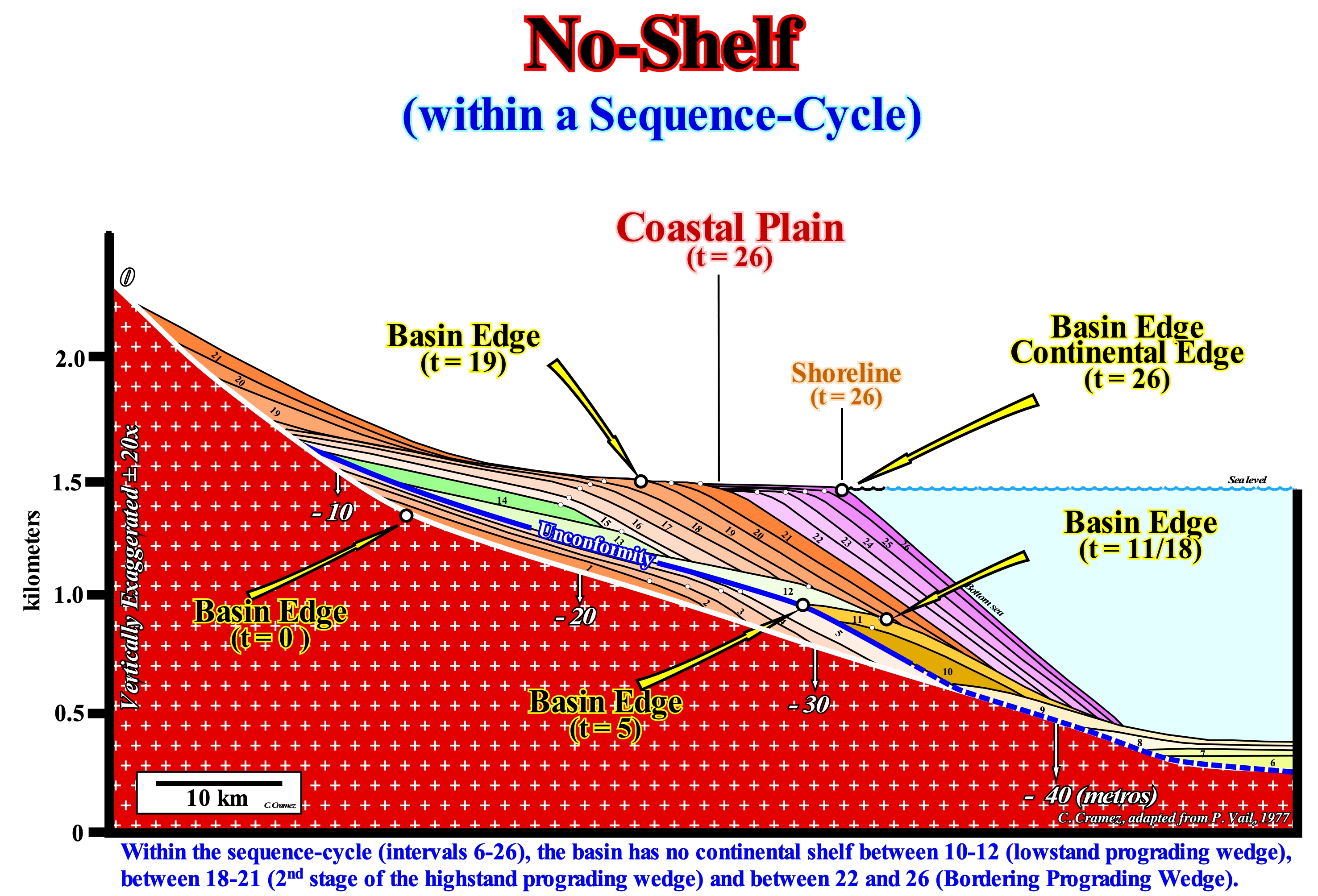
In this EPR (Exxon's "Exploration Production Research") geological model, in which two sequence-cycles, induced by two 3rd order eustatic cycles, characterized by a time-duration ranging from 0.5 to 3-5 My, are illustrated (the lower sequence-cycle is incomplete), it should be noted that: (i) Each stratigraphic interval from 1 to 26, i.e., each sequence-paracycle, bounded between two consecutive marine ingressions represents a period of 100,000 years ; (ii) The area of each of these stratigraphic intervals is constant, which simulates a constant terrigeneous influx ; (iii) The subsidence of the basin edge* (t = 0 to t = 26) increased linearly and steadily seaward ; (iv) Erosion was considered negligible ; (v) The vertical scale is exaggerated by more or less 20 times, which implies a significant deformation of the geometric relationships between the chronostratigraphic lines and the surfaces defined by their terminations. During the stratigraphic intervals defined by time intervals 10-11 and 18-26, of the upper sequence-cycle (6-26), the sedimentary basin has no continental shelf and the coastline, which corresponds, more or less, to the depositional coastal break of the depositional surface (especially in the seismic lines), coincides with the continental edge (upper limit of the continental slope). During these intervals, upstream of the basin edge, we find, directly, the coastal plain, since the basin had no shelf. This geological situation developed during the lowstand prograding wedge (LPW), between 10 and 11 and during the 2nd stage of development of the highstand prograding wedge (HPW), between 18 and 21, as well as during the bordering prograding wedge (BP) **, between 22 and 26. At the end of the transgressive interval (12-14), the basin has a platform. The shoreline is very far from the basin edge, since the extension of the continental shelf is maximum. As the relative sea level (local sea level referenced to any point on the Earth's surface, which may be, for example, the base of the sediments i.e., the top of the continental crust or the sea floor) has begun to rise in deceleration (the marine ingressions are increasingly smaller), i.e., at the beginning of the highstand prograding wedge (15), the basin still had a platform. However, progressively, as the coast line progrades seaward, the distance between it and the basin edge decreases, which means that the extension of the platform decreases. From the end of the first phase of development of the highstand prograding wedge (HPW), i.e., when the shoreline and the coastal slope (slope associated with the depositional coastal break of the depositional surface, which sometimes corresponds to a prodelta) fossilized the basin edge, the platform disappeared (beginning of the 2nd stage of development of the highstand prograding wedge). A new continental edge forms, since the shoreline is no longer, clearly, individualized from the continental edges. The outer boundary of the coastal plain became the new continental edge and also the new basin edge. Under these conditions, a small instability of the continental edge or an excess of terrigeneous influx (flooding of a river, for example) can initiate turbidity currents along the continental slope. Since these currents reach the abyssal plain, the transported material is deposited in the form of submarine fans (E. Mutti depositional model for many turbidite deposits). These submarine fans are not associated with the lowstand geological conditions imposed by the P. Vail model, i.e., they are not associated with erosional surfaces (unconformities) induced by significant relative sea level falls. In the field, as in this model, a marine ingression increases the space available for the sediments creating in the pre-existing topography a ravinment surface, but there is no deposition of sediments. Deposition occurs during the stability period of relative sea level following a marine ingression, as the shoreline, progressively, moves seaward.
(*) Within a sequence-cycle, the location of the basin edge varies. During the deposit of the lowstand systems tract group (SBFF, SSF and LPW) the basin edge is the most recent basin edge of the preceding sequence-cycle, since the basin has no continental shelf. As the basin acquires a continental shelf, that is, from the first transgressive surface (beginning of the transgressive interval, IT), the basin edge becomes the outer edge of the platform, that is, the continental edge, until that during the deposition of the highstand prograding wedge, the progradations, completely, fossilize the continental shelf. From that moment, beginning of the 2nd stage of development of the highstand prograding wedge (HPW), the basin has no platform and the basin edge becomes the new continental edge that coincides, more or less, with the shoreline.
(**) The bordering prograding wedge (BPW), following small modifications, induced by field observations (1:1 scale), was called depositional descending systems tracts (DDST), corresponding, more or less, to what is today geoscientists call a forced regression (FR).
Nodal Point (Wave)..................................................................................................................................................................................................Point Nodal
Ponto nodal / Punto nodal / Knotenpunkt / 结点 / Узел (узловая точка) / Punto nodale /
Point where the waves interfere destructively, i.e., the point on a standing wave where the vertical motion is the smallest and the horizontal velocity is the largest.
See: « Wave »
&
« Crest (wave) »
&
« Hollow (wave) »
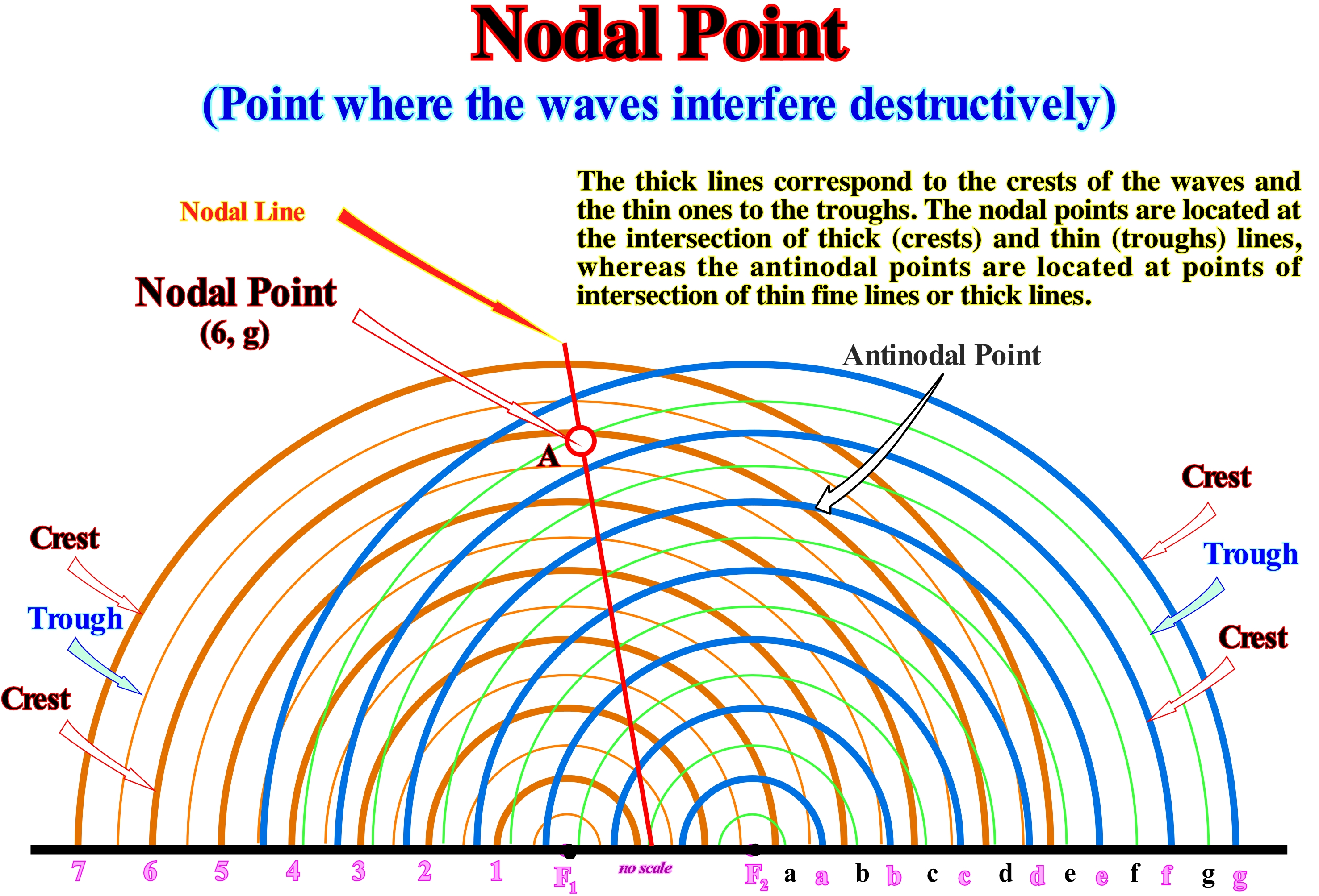
A nodal point is a point along a stationary wave, where the wave has a minimum amplitude. For example, on a vibrating guitar string, the ends of the string are the nodes or nodal points. By changing the position of a nodal point a guitarist modifies the effective length of the vibrating string and thus the note played. The opposite of a nodal point is the antinodal point, in which the amplitude of the standing wave is maximal, which, in this particular case (guitar string) occurs midway between the nodal points. A wave is a disturbance that propagates through space and time, transferring energy. A standing wave is a wave that remains in a constant position. This type of wave occurs because the medium travels in the opposite direction of the wave, or it may arise in a stationary medium as a result of interference between two waves traveling in opposite directions. In this second case, for the waves of equal amplitude traveling in opposite directions, there is on average no evidence of energy propagation. When two waves moving in the same direction, interference produces a displacement wave (when the wave appears to travel through a medium, i.e., when a crest is followed by a trough which in turn is followed by another crest and so then). This figure illustrates the pattern resulting from the propagation of water waves across the surface of a water-body. The waves propagate from the sources of vibration, forming a series of concentric circles around the sources of vibration. The thicker lines represent the crests of the waves, and the thin lines of the waves. The crests and troughs of the two sources interfere with each other producing nodal and antinodal points along the water surface. The nodal points are located where the water is not disturbed, and the antinodals where the water suffers the maximum of disturbances. One of the characteristics of the interference pattern of two source points is that the antinodal and nodal positions are arranged in separate lines. Each line can be described as a hyperbola and the spatial separation between the antinodal and nodal lines is related to the wavelength of the waves.
Nodic Period (Moon).............................................................................................................................................................Période nodique (Lune)
Período nódico / Período nódico (de la Luna) / Nodic Zeitraum / 脑力期 / Нодический период (Луна) / Periodo Nodico /
Time that the moon takes to go from a node (each of the points where the moon's trajectory intercepts the ecliptic and where the third coordinate of the moon is increasing) and return to the same node, which is equal to 27.21220 days. Same as Lunar Month. Synonym with Draconic Period or Draconic Month.
See : « Sidereal Period (moon) »
&
« Ecliptic »
&
« Orbit »
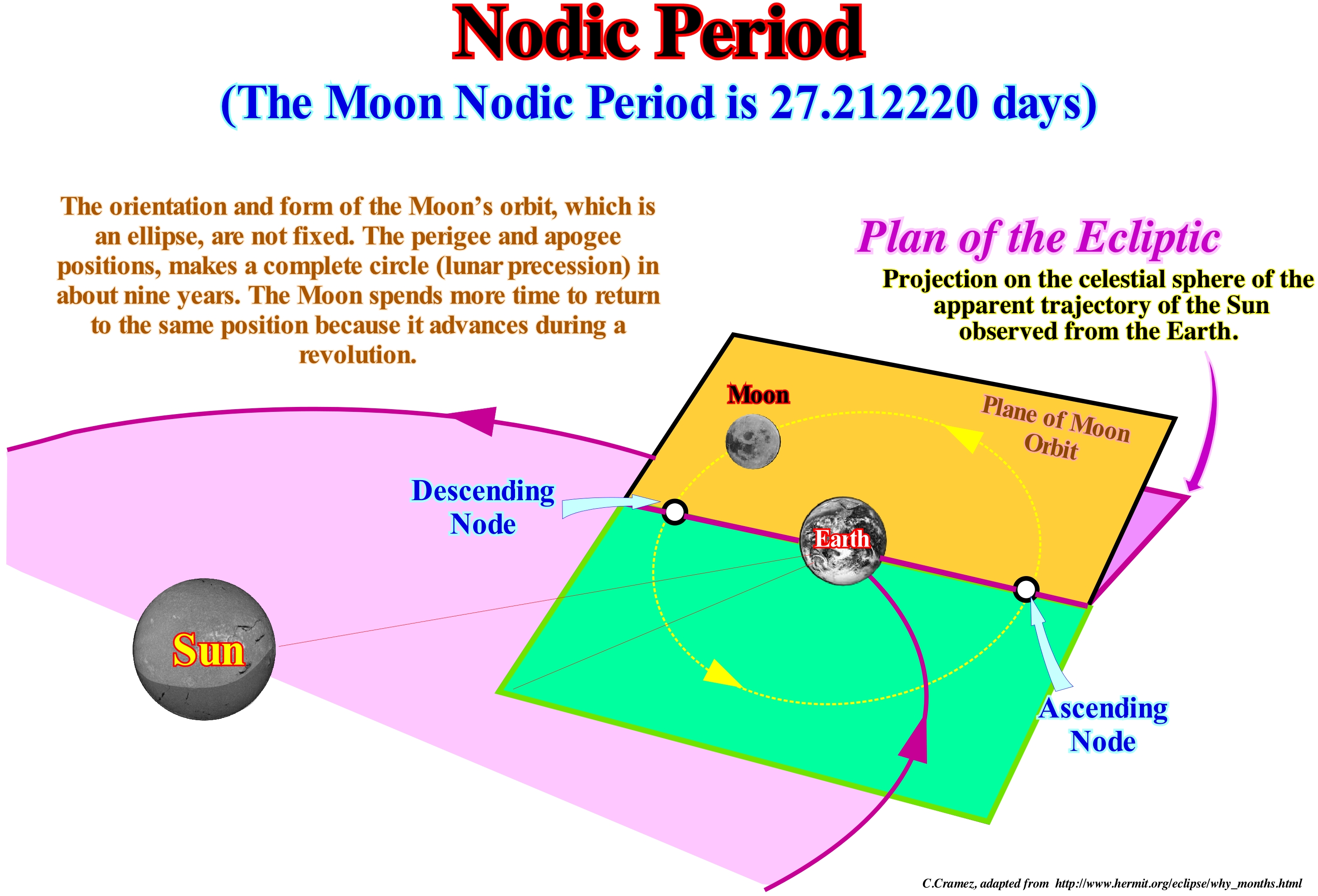
The Moon's orbit is inclined to the plane of the ecliptic. The points of intersection of the orbit and the ecliptic are the nodes (ascending and descending). The Moon to be, directly between, the Earth and the Sun must be in the same plane of the ecliptic and in one of the nodes. The time the moon spends from a node along its orbit and return to the same node is not, exactly, the same as a simple orbit due to the precession of the Moon's orbit. The orbit plane as well as the nodes rotate back around the Earth once every 18.6 years. The time the Moon spends to return to the same node (where it left off) is smaller than the orbital period. It is equal to 27.212220 days and is called node period or month nodic (also, called draconian). In addition to the nodic or draconic month, there are other ways of considering how long it takes the Moon to complete an orbit: (i) Sidereal month, which is the time the Moon takes to make a complete return to Earth in relation to the fixed stars, which lasts about 27.3 days ; (ii) Synodic month, which is the time the Moon spends between two phases (between two consecutive New Moons), which lasts about 29.5 days ; (iii) Tropic month, which is the time between two consecutive phases of the Moon (same ecliptic longitude). The synodic month is longer than the sidereal month because the Earth-Moon system shifts a finite distance in its orbit around the Sun during each sidereal month and more time is needed to find the same relative geometry. As a result of the slow precession of the Moon's orbit, the month or anomalistic, tropic and draconic period are different from the sidereal month. The average time of a calendar month (1/12 of a year) is about 30.4 days. Do not forget that the Moon's orbit is tilted relative to the plane of the ecliptic and that the points of intersection of the orbit and ecliptic are the nodes (ascending and descending). The Moon to be in alignment and between the Earth and the Sun, must be in the same plane of the ecliptic and in one of the two nodes. Therefore, the time the Moon spends to go from a node along its orbit and back is not exactly the same as the time of a single orbit due to the precession of the Moon's orbit. The plane of the Moon's orbit, as well as the nodes, rotate back around the Earth once every 18.6 years. The space between two moon passages in the perigee (point of the orbit of a star or an artificial satellite closest to the Earth, the point opposite the perigee is the apogee), which is about 356,375 km from our planet , is called the anomalistic revolution period, which is about 27.55 days, or more exactly, 27 days, 13 hours, 18 minutes and 33.1 seconds.
Nomogram (Alignement chart)............................................................................................................................................................Nomogramme
Nomograma / Nomograma / Nomogramm / 诺谟图 / Номогра́мма / Nomogramma/
Two dimensions diagram, that allows to calculate, graphically, in more or less approximate way, a function. Synonym of Abacus.
See: « Dipmeter Log »
&
« Logistic Curve »
&
« Hubbert's Curve »
A nomogram, abacus, or nomograph is a graphical calculating tool, a two-dimensional diagram that allows approximate graphing of a function of any number of variables. In its more general conception, the nomogram represents, simultaneously, the set of equations that define a certain problem and the total possibility of its solutions. It is an analog calculation tool, such as a calculation rule, for using continuous segments of lines to represent the discrete numerical values that can assume the variables. Their accuracy is limited, being determined by the detail with which they can be realized, reproduced, aligned and perceived the marks or concrete points that constitute the corresponding scales of values. Nomograms should just be used in cases where obtaining an exact answer is impossible or very inconvenient (complicated engineering calculations to be carried out in battles or on the construction site; repetitive situations with slight changes in the values of the variables; etc.), where obtaining an approximate solution is sufficient and very desirable. A nomogram has, usually, three scales. Two scales represent the known values and a scale is the scale where the result is read. The best known scales are placed outside, i.e., the scale of the result in the centre. Each known value of the calculation is marked on the external scale and a line is drawn between each mark. Where the line and the inner scale intersect is the result. The nomogram shown in this figure is widely used in oil research, since from the time-temperature index (basin maturation), the geothermal gradient and burial of potential source-rocks (maximum depth reached by the source-rocks, it is possible to determine : (i) The limits of thermal maturation , (ii) The end of oil generation, (iii) The peak of oil generation, (iv) The probability of sealing, i.e., of rocks with characteristics of sealing-rocks ; (v) The beginning of oil generation. Note that the ITT scale (time-temperature index) is logarithmic*.
(*) Nonlinear scale used for a large range of positive multiples of some quantity. Scale that uses the logarithm of a magnitude instead of the magnitude itself. The logarithm reduces the representation to an easier scale to be visualized. A logarithmic unit is a unit that can be used to express a quantity on a logarithmic scale, i.e., as being proportional to the value of a logarithm function applied to the ratio of the quantity and a reference quantity of the same type. Note that the base logarithm of a strictly positive real number is the power at which the base b must be raised to obtain this number. For example, the logarithm of 1000 in base 10 is 3 because 1000 = 10 × 10 × 10 = 103. The logarithm of x in base b is noted logb (x). So log10 (1000) = 3.
Nomogram (Abacaus)..........................................................................................................................................................................................................Abaque
Ábaco / Nomografía / Nomogramm / 计算图表 / Номограмма / Nomogramma /
Graphical representation composed of several lines, with different scales, arranged in such a way that connecting the known values on two lines an unknown value can be read at the point of intersection with another line. A typical abacus has three scales. Two scales represent known values. The other scale is the scale where the result can be determined. Scales can be linear or logarithmic*. Synonym with Abacus.
See: « Logistic Curve »
&
« Hubbert's Law »
&
« Oil Window »
In this figure, in the upper right, an abacus or nomogram, as certain geoscientists call it, is basically a graph that serves to represent equations, with several variables, in a plane. This type of representation reduces the calculation of the solutions to a simple reading made in the abacus. In this example, this means that if we know the values of A (in the abscissa axis, that is, the horizontal coordinate, which serves to fix a point in a plane) and B (in the ordinate axis, i.e. the coordinate vertical, which in this case serves to fix a point in the Cartesian coordinate system), we can determine the value C by joining the values of A and B. Most of the abacuses have a coordinate system different from the Cartesian system. The abacuses are widely used in petroleum research, where certain properties, such as the porosity of a rock-reservoir (rock with porosity and permeability characteristics, allowing the accumulation and circulation of hydrocarbons and water) can be determined indirectly from of values of other properties measured in the electrical diagrams. The porosity of a rock-reservoir, which depends mainly on: (i) Degree of burial, which determines, in part, the compaction; (ii) Thermal regime and (iii) Fluid percolation can be determined directly from the borehole samples. The main abacus of this figure ("Oilfield Size" versus "Ordering or Ranking") has logarithmic scales. It clearly shows that the size distribution of oil fields (more or less 95% of the world's fields) is (a few giant fields and many small fields) and that the sum of the reserves has, practically, reached its maximum, which means that, at the beginning of the millennium, the peak of oil (peak oil production)** no longer it was too far away.
(*) The logarithm is an exponent that we give to a reference number, called base, to express a certain number. For example, 2 is the logarithm of 100 in base 10, since 102 (ten squared) is equal to 100. When the number 10 is used as the base, the exponent is a common logarithm. Natural logarithms use the number 2.718 ...., that is, "e", as the basis. This number that is used in all branches of science is the value reached in a unit of time by a unit of quantity which always grows at a rate equal to itself. For example, a chicken that weighs 1 kg on 1 January and grows at a rate equal to its own weight (when it weighs 1.2 kg it is fattened at the rate of 1.2 kg per year), after one year weighed 2.718 ... kg = e kg. A logarithmic scale is a measurement scale that uses the logarithm of a physical quantity instead of the quantity itself. A simple logarithmic scale shows divisions equally spaced on the vertical axis of a chart marked with 1, 10, 100, 1000, etc.
(**) When the oil production peak of a oilfield is reached, it can be said about half of the reserves have already been produced and the price of production will increase rapidly. Likewise, when the global sum of discovered reserves does not increase significantly, it can be said that there are, practically, no more significant fields to be discovered.
Nonconformity.........................................................................................................................................................................................Non-conformité
Não-conformidade / No-conformidad / Nichteinhaltung / 非整合 / Стратиграфическое несогласие / Non-Conformità /
Surface that separates different types of rocks, such as a surface between metamorphic and sedimentary rocks. In general, a nonconformity corresponds to an unconformity, but not always. It can often be confused with conformity, particularly in saline basins (tectonic disharmony).
See: « Unconformity »
&
« Relative Sea Level Fall »
&
« Erosion »
A discontinuity designates a transition or contact between intervals with either different densities (Mohorovičić discontinuity) or with different sedimentary facies, or between intervals separated by a hiatus. There are several types of discontinuities: 1- Stratigraphic ; 2- Sedimentary ; 3-Lithologic ; 4- Tectonics, etc., Within the lithological discontinuities can be recognized: (i) Concordant discontinuities, when there is continuity between successive intervals ; (ii) Paraconform Discontinuities or Paraconformities, when there is no difference in attitude between overlapping intervals, but there is a hiatus due to the absence of significant deposition between them ; (iii) Nonconform Discontinuities or Nonconformities, when there is a contact between a sedimentary interval and an older igneous body ; (iv) Discontinuous Discontinuities or Disconformities, when the layers of the intervals are parallel on one side and the other side of the contact surface which does not conform to the regional stratification ; (v) Discordant Discontinuities or Unconformities when the two intervals are separated by an erosional surface induced by a relative sea level fall ; (vi) Reinforced Discordant Discontinuities or Tectonically Enhanced Unconformities, when the sediments of the interval overlying an unconformity were deformed by tectonics ; (vii) Intrusive Discontinuities, when an igneous body traverses a sedimentary series ; (viii) Mechanical Discontinuities, when they are induced by faults,etc. (https://estpal13.wordpress.com/2013/06/04/discontinuities-sedimentary-and-stratigra-phic/). For many geoscientists, a nonconformity corresponds to an unconformity, i.e., to an erosional surface, in particular, when it is not exaggerated by tectonics (angular unconformity). This expression is used, above all, when, apparently, an interface seems conform but, in reality, it is not. In a seismic line, the lower and upper unconformities limiting a stratigraphic cycle, such as the boundaries of a sequence-cycle, are just evident where the terminations of the chronostratigraphic lines correspond to onlaps or toplaps by truncation. In general, unconformities may be evident near the continental edge (which may or may not coincide with the basin edge), when there are filling of submarine canyons and, in certain zones of the coastal plain, when the occurrence of incised valleys fillings allows to recognize the erosional surface that characterizes them. In most cases and, especially, when unconformities are not exaggerated by tectonics, they correspond to nonconformities, since they appear to be concordant, but they are not, since they represent an important hiatus. A nonconformity always exists between a basement and the overlying sedimentary rocks, even if the interface is parallel to the chronostratigraphic lines of the sedimentary rocks. As illustrated on this tentative geological interpretation of a Canvas auto-trace of an Angola offshore seismic line , which corresponds to the stacking of several types of basins from the classification of the sedimentary basins of Bally and Snelson (1980), certain geoscientists divide the stratigraphic column into two large intervals separated by a saliferous horizon or by the tectonic disharmony associated, almost always, to the top of the salt interval. In this offshore, it can be said that between the infra and supra-salt sediments, when they are separated by a salty weld, there is always a nonconformity. However, a salt weld does not correspond to an erosional surface. It can not be considered as an unconformity (as defined in sequential stratigraphy), since there is no erosion associated with a significant relative sea level fall but simply as a tectonic disharmony induced by a total lateral flow of the evaporites, in general, salt, which creates a hiatus between the supra and infra-salt sediments. As can be seen on the tentative interpretation, the infra-salt sediments, that is, the lower sediments of the divergent margin (Atlantic type) and the sediments of the rift-type basins, are not deformed, which contrasts with the deformation in extension (lengthening ) of the suprasalt sediments. The "turtle-back" structure illustrated on this tentative interpretation corroborates the lengthening of the supra-salts sediments. The normal faults at the apex of the structure, as well as, the divergent internal configuration of the sedimentary intervals, characterize the deformations associated with the salt movements.
Nondeposition Toplap........................................................................................................Biseau supérieur de non-dépôt
Bisel superior sem-depósito / Bisel superior sin-depósito / Bevel Higher nicht Anzahlung, Ohne Fase up - Einreichung, Non-Deposition toplap / 没有伞起来 - 备案 / Кровельное прилегание без напластований / Bisello superiore non deposizionale /
Tolap created by the seaward displacement of the depositional coastal break due to lack of available space (shelfal accommodation) for the sediments. This type of toplap is, often, associated with a small relative sea level fall which is not sufficient for the continental shelf be totally exhumed (P. Vail type II unconformity) or, in other words, when erosion, if it exists, is local and insignificant.
See: « Toplap »
&
« Unconformity »
&
« Erosion »
The North Caucasus onshore corresponds to a folded mountain range from the classification of the sedimentary basins of Bally and Snelson (1980), which resulted from the collision of two Mesozoic/Cenozoic divergent Atlantic-type and underlying rift-type basins created by the break-up of the Pangea supercontinent . Nondeposition toplaps are, easily, recognized on this tentative geological interpretation of a Canvas auto-trace of a detail of an onshore seismic line at the top of the progradational or regressive intervals. On this tentative interpretation, the seismic intervals with a progradational geometry are predominant. Within a sequence-cycle, these intervals are associated with relative sea level rises in acceleration, i.e., increasingly smaller marine ingressions that displace continentward the depositional coastal break of the depositional surface (more or less the shoreline, particular on the seismic lines). During the stability period of relative sea level, which occurs after each marine ingression, sedimentation resumes, with the deposition of increasingly important sedimentary regressions, that move the shoreline seaward, which, at the end each sedimentary regression is near the open sea. These displacements induce nondeposition toplaps, since, upstream of the depositional coastal break, there is no space available for the sediments settle down. Within a sequence-cycle, at the beginning of deposition of the highstand prograding wedge (HPW), when the relative sea level has ceased to rise in acceleration and started to rise in deceleration, the depositional coastal break of the depositional surface is displaced seaward (function of the terrigeneous influx), i.e., the shoreline approaches the continental edge and the water-depth decreases. This means that, progressively, the shelf of the basin disappears (no continental platform). Since the basin edge, which during the first stage of development of the highstand prograding wedge (HPW) was, more or less, distant from the shoreline, becomes almost coincident with it and becomes the new continental edge (when the shelf is, totally, fossilized by progradations of the highstand prograding wedge), since then the basin has no longer a shelf. There are all intermediate cases between the nondeposition toplaps and toplaps by truncation (or by erosion). It is, often, difficult to decide to what extreme type a toplap should be associated with. Theoretically, a nondeposition toplap must be marked by oblique progradations, i.e., by chronostratigraphic lines represented just by the intermediate segment dipping seaward (without the upper and lower subhorizontal segments). In this particular case, between two chronostratigraphic lines, the aggradation (vertical deposition) is, practically, null. The progradation (lateral deposition) is, largely, predominant. The great majority of the progradations visible in the auto-traces, as illustrated on this tentative interpretation, are sigmoid, i.e., that there is a significant aggradation between two consecutive chronostratigraphic lines. In these cases, the expression nondeposition toplaps is somewhat abusive. The term toplap by non erosion seems to be more appropriate because when the relative sea level rises, in deceleration, there is almost always a slight aggradation, whose amplitude is often lower than the seismic resolution. Only when toplaps are induced by small falls of relative sea level (local sea level referenced to any point on the Earth's surface, which may be the base of the sediments or the sea floor, and which is the result of the combined action of the absolute or eustatic sea level and tectonics) the aggradation is negative. Under these conditions many geoscientists speak of falling depositional systems tracts and others speak of forced regressions. However, in this case, it should be asked whether the designation of nondeposition toplaps is appropriate. The great majority of American geoscientists consider that when there is no aggradation between consecutive progradations, but just lateral accretion (outbuilding), they belong to the family of oblique progradations. On the contrary, they are considered sigmoid progradations when there is a significant aggradation between them. This differentiation is important, since the probability of finding reservoir-rocks in the dipping or lower horizontal segment is much greater in the oblique progradations than in the sigmoid progradations.
Nondeposition Hiatus..............................................................................................................................Hiatus de non-déposition
Hiato sem deposição / Hiato de no-depositación / Non-Ablagerungsbedingungen Hiatus / 非沉积间断 / Неосадочный разрез / Iato non deposizionale /
Hiatus associated with geological surfaces characterized by an absence of deposition. The geometric relationships associated with a non-depsotional hiatus are: (i) Onlaps ; (ii) Downlap Surfaces and (iii) Toplaps. This hiatus translates the geological time span during which any stratum was deposited on the depositional surface. Synonym with Depositional Hiatus.
Ver: « Hiatus »
&
« Unconformity »
&
« Downlap Surfaces »
In general, a hiatus is a rupture or interruption in the continuity of the geological record, such as the absence in a stratigraphic sequence of rocks that should, normally, be present but have never been deposited or eroded prior to the deposition of the overlying layers (R. Bates & J. Jackson, 1980). A hiatus without deposition is, often, considered as the time value of an episode of nondeposition or nondeposition and erosion together. These sketches illustrate different cases of a hiatus without deposition (hiatus of deposition for certain geoscientists) in different sedimentary environments. The determination of the geometric relationships between the strata (or chronostratigraphic seismic reflectors) and the internal configurations of the intervals separated by the hiatus is very important, since they can define downlap surfaces or onlap surfaces, which of course, translate different geological histories. In the first sketch (1), successive downlaps (subaqueous environment) define a downlap surface of a regressive sedimentary interval** that fossilizes a nondeposition hiatus, which increases downstream (seaward). The upper terminations of the reflectors of this same regressive interval (or progradational) define a terminating surface of toplaps (subaerial environment), which may have been produced by an unconformity, i.e., by a significant relative sea level fall (erosional surface) or by a transfer zone (area through which sediments are transported without depositing). In the first hypothesis, the hiatus is of erosional, but in the second, the hiatus is by nondeposition. In the second sketch(2), the upper terminations of the reflections of the progradational interval (or regressive) are not visible, therefore, only the lower hiatus associated with the downlap surface is significant. The hiatus is nondepositional, since the interval is progradational. That is why in sequential stratigraphy, the downlap surfaces (subaqueous environment) are not boundaries of the stratigraphic-cycles, since they are not induced by a significant the relative sea level fall. They are not erosional surfaces. However, they may coincide with the boundary of a stratigraphic cycle (sequence-cycle or not), in the very distal part of the basin, when the late progradations of the highstand prograding wedge (HPW) can end, directly, on sediments of the underlying stratigraphic cycle. The third sketch (3) reflects a particular case in which the uplift (not necessarily associated with a regional shortening***) of the lower conform sediments was not sufficient, at least locally, to place them in a subaerial environment, which means, that they were, practically, not eroded. On the other hand, the onlap of the overlapping cycle fossilize a nondeposition hiatus rather than an erosional hiatus. The onlaps, in this case, distal onlaps, which have been deposited in an subaqueous environment. It is important not to forget that in sequential stratigraphy, to have an unconformity, there must be erosion and to have erosion the sediments must be exposed to erosive agents and for that the relative sea level must fall below the basin edge (which, is generally, located upstream of the continental edge when the basin has a continental shelf.
(*) For many geoscientists, this does not necessarily mean that nothing happened during that time, but simply that nothing was preserved in the stratigraphic record, which is not the same thing. If it is true that 80% or more of the sedimentary activity of a given moment and in a given place is not recorded (Pareto law), then it can be said there is a hiatus, because, in this place and at that time, there is no sedimentary material that geoscientists can study, which does not mean that there is enough material to be studied elsewhere. These temporal hiatus can be large (from 0 to 1000,000 y). They suggest that there may be negligible deposition or continuous erosion at a particular location.
(**) The term regressive sedimentary interval is somewhat redundant. Almost all clastic deposits are by definition progradational, particularly, the marine deposits although, at times, the slope of the progradations are so small, that at large scale (scale of the seismic lines, for example) they appear as subhorizontal. Within a sequence-cycle, for example, except the submarine basin floor fans (SBFF) and submarine slope fans (SSF), which are deposited during significant relative sea level falls, all other subgroups of sedimentary systems tracts are deposited during the stability periods of relative sea level, as the shoreline moves seaward and upward (progradation or outbuilding and aggradation or upbuilding).
(***) The uplifting a diapiric salt structure, for instance, lifts the overlying sediments, but does not shorten then. On the contrary, the overlying sediments are, more or less, lengthening by normal faults induced by a local tectonic regime characterized by an ellipsoid of the effective forces with vertical σ1 and σ2 = σ3 horizontal and perpendicular to each other.
Nonmarine Onlap....................................................................................................................Biseau d'aggradation non-marin
Bisel de agradação não-marinho / Bisel de agradación no-marino / Non-marine onlap, Bevel Verlandung nicht Marino / 海洋上超 / Неморское подошвенное налегание / Non-marine onlap, Bisello d’aggradazione no-marina /
Onlap observed in nonmarine sedimentary environments, i.e., in the sedimentary environments located upstream of the depositional coastal break (more or less the shoreline). Many nonmarineonlaps do not underline (even approximately) the sea level since many of them are not controlled by relative sea level changes, since the available space for sediments is not created by eustasy, but by allocyclic mechanisms (internal or that belong to the depositional system itself).
See: « Onlap »
&
« Aggradation »
&
« Depositional Shoreline Break »

The Sudan onshore corresponds to the stacking of two types of basins of the classification of the sedimentary basins of Bally and Snelson (1980), that from the bottom to top are: (i) Rift-type basins developed by a differential subsidence in association with the extension of the lithosphere of the Gondwana small supercontinent (Precambrian Basement or Paleozoic sediments) and (ii) A cratonic basin created by a thermal subsidence. The former have a geometry of halfgraben, a relatively small lengthening and a divergent internal configuration (in the direction of halfgraben edge) or parallel. The cratonic basin is, generally, very extensive, more or less, circular in shape, relatively, thin and almost always with a parallel internal configuration. An unconformity (erosional surface), sometimes locally, tectonically enhanced (angular unconformity) separates these two types of sedimentary basins. For some geoscientists, in this type of sedimentary overlap (rift-type basins underlying a cratonic basin), the thermal subsidence, which characterizes the cratonic basin, corresponds to a rebalancing of the isotherms, which contracted during the lengthening of the lithosphere of the Gondwana small supercontinent (however, no one yet knows if it is the sedimentary lengthening that contracts the isotherms or the opposite). On this tentative geological interpretation of a Canvas auto-trace of a detail of a seismic line of this onshore, we perfectly recognize two rift-type (halfgrabens) basins covered by a cratonic basin, relatively, thick, whose sediments dip, slightly, westward. The rift-type basins are separated from the cratonic basin by an unconformity, probably, associated with a reactivation of the normal fault bordering the halfgrabens, which created a small shortening at the end of the lengthening phase and not a possible oceanization, since in this the area the lithosphere did not broke-up. An unconformity is an erosional surface induced by a significant relative sea level fall. The rift-type basins develop in non-marine environments, upstream from the depositional coastal break of the depositional surface, where relative sea level changes have little influence, in particular, in the creation of available space for sediments (shelfal accommodation). The sediments filling by onlapping the rift-type basins are, probably, lacustrine with horizons rich in organic matter. They characterize associated a nonmarine aggradation. These nonmarine onlaps were, slightly, tilted eastward due to movement along the fault plane (differential subsidence contemporaneous of sedimentation). They should not be interpreted as original downlaps but rather as deformed or tilted onlaps. Taking into account the internal configuration of the seismic reflectors filling the halfgrabens, which geometry at some levels is, more or less, parallel, it is very likely that the sediments at these levels have been deposited in a lacustrine environment. Such a configuration not only suggests a, relatively, substantial water-depth deposition but also the deposition of the shales and organic sedimentary particles. In the exploration drilling wells drilled in this onshore, several levels of organic rich lacustrine shales were found source-rocks that produced the hydrocarbons found in the oil fields of the area. A giant oil field (Unity Field) is located at the far left of this tentative interpretation. Empirically, it can be said when the internal configuration of a rift-type basin is, more or less, parallel, there is a strong probability that lacustrine rocks rich in organic matter have been deposited therein, i.e., it contains source-rocks. On the contrary, when the internal configuration of a rift-type basin is, more or less, divergent, there is little likelihood that potential lacustrine source-rocks were deposited. Using the geometric relationships between reflectors that fill these two types of rift-type basins in a geological reconstruction, the presence of a significant water-depth (a lake for example) is required in the rift-type basin with a parallel internal configuration , while in the other basins (divergent configuration) the depositional water-depth is always close to zero.
Nonmarine Source-Rock...................................................................................................................Roche-mère non-marine
Rocha-mãe não-marinha / Roca madre no marina / Nicht-Marine Muttergestein / 无海相烃源岩 / Неморская материнская порода / Roccia fonte non-marina /
Nonmarine sedimentary rock (continental or lacustrine) rich in organic matter, which was, sufficiently, buried generating hydrocarbons capable to develop economic accumulations.
See: « Sealing-Rock »
&
« Source-Rock »
&
« Reservoir-Rock »
As illustrated on this tentative geological interpretation, in depth and in facies (lithology), from a Canvas auto-trace of an Indonesia offshore seismic line, the coals and delta plain organic rich shales are examples of nonmarine source-rocks. In this area, all organic matter is type III and, in general, it generates, mainly, gas with a little associated oil. A few years ago, when the price of a barrel of oil did not exceed 10 USA $ and there was no market for gas, most of the fields discovered in this area were considered as oil fields. At present, no one has more trouble to consider, that the fields, fed by these nonmarine source-rocks, are huge gas fields with a little oil, even if the Handil field, for instance, produced more than 1.5 Gb. It is interesting to note that these nonmarine organic sediments (coal and clay of the delta plain) can form source-rocks in marine environments, particularly, deep marine. In this area, as the delta building progressed seaward, during the relative sea level falls, the sediments of the delta plain, i.e., coal and shales rich in organic matter (type III), were eroded and transported to the deep-marine environments of the basin by turbidity currents, where they are deposited, either in submarine basin floor fans or submarine slope fans. Under certain conditions, turbidite deposits may not only be considered as potential reservoir source-rocks, but also as potential marine source-rocks, since they have a non negligible quantity of dispersed organic material. Although the charge of such nonmarine source-rocks (transported and dispersed continental organic matter) is very small, if the thickness of the turbidite deposits is, sufficiently, large and if the type of migration of the hydrocarbons converges to certain areas (structural highs), they can feed profitable accumulations even under an important water-depth, as is the case downstream of the area illustrated by this tentative interpretation (East of Borneo offshore or Kalimantan offshore). Note that in the computations illustrated above, the simple moving average (MMS) calculates the mean through the most recent values in a data series.
Nonmarine Toplap........................................................................Biseau supérieur de progradation non-marin
Bisel superior de progradação não-marinho / Bisel superior de progradación no-marino / Progradierender Keil überlegen nicht-marine, Non-marine toplap, Superior-Bevel nicht Marino Progradation / - 海洋顶超 / Неморское кровельное прилегание / Bisello superiore di progradazionale non-marine /
Toplap in nonmarine sedimentary environments, i.e., located upstream of the depositional coastal break. The vast majority of geoscientists and, in particular, the specialists in Sequential Stratigraphy consider that the bay-line is the lower (downstream) boundary of fluvial deposits. Coastal plain deposits, located between the bayline and the depositional coastal break, which is, more or less, the shoreline, are sometimes considered as nonmarine rather than fluvial, since they may be influenced by relative sea level changes. Fluvial deposits, themselves, in the sequential stratigraphy, are located upstream of the bayline, which emphasizes, upstream, the onlapping of the coastal prism of Posamentier and Vail (1992).
See: « Clay Plug »
&
« Downlap »
&
« Depostional Environment »
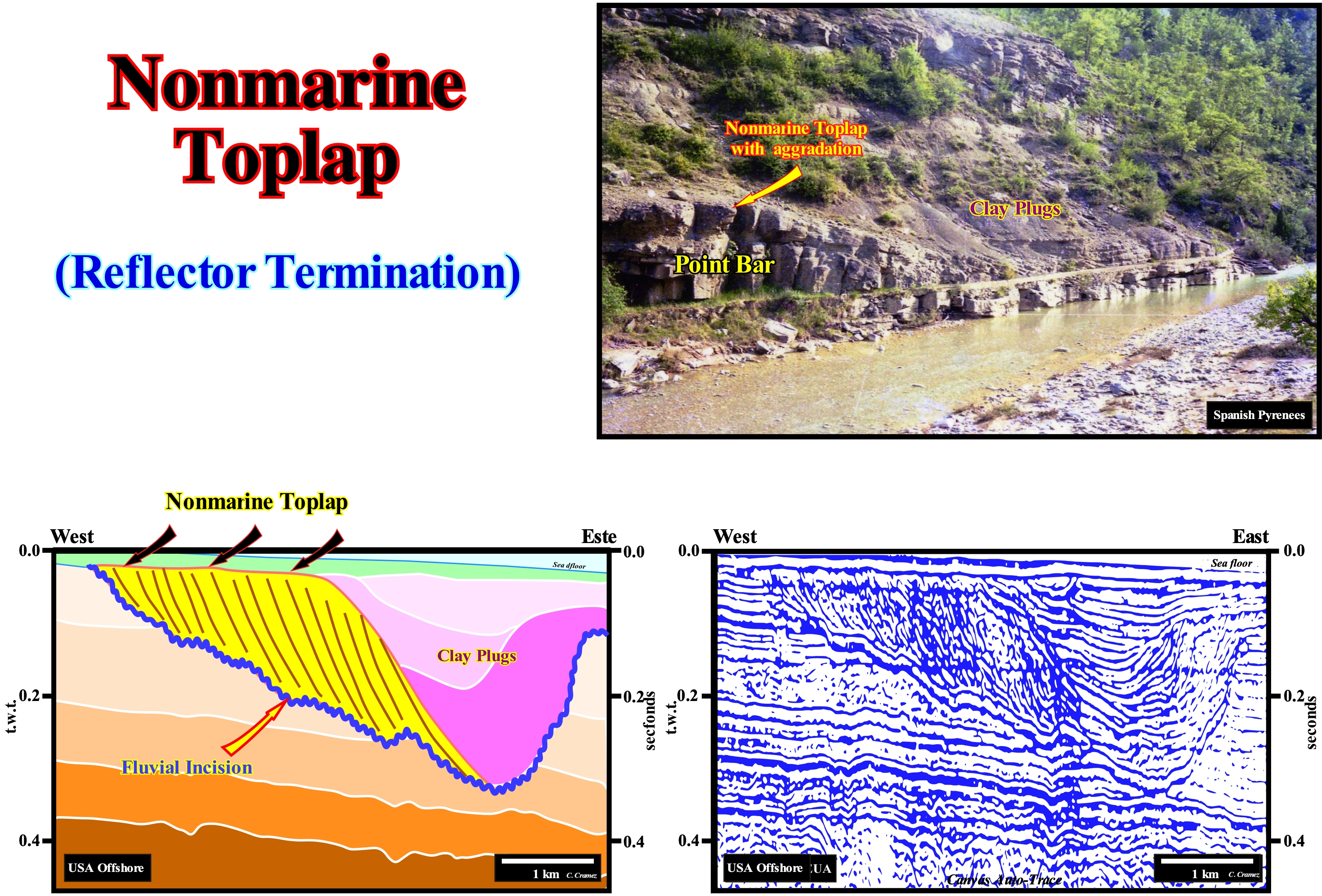
When nonmarine depositional systems are inferred in seismic lines, as illustrated on this tentative geological interpretations of a Canvas auto-trace of a Gulf of Mexico seismic line, lithological predictions from seismic data are just possible under certain conditions. This is particularly true when nonmarine depositional systems are influenced by changes in relative sea level (local sea level, referenced to the sea floor or the base of the sediments, i.e., to the top of the continental crust) that is to say, where the eustatism* influence is still felt. In nonmarine deposits, upstream of the depositional coastal break of the deposition surface (which on seismic lines, taking into account the seismic resolution, practically, corresponds to the shoreline) and downstream of the bayline (the boundary between the fluvial and the paralic/deltaic environments), where relative sea level changes have little influence on accommodation, lithological predictions require a good understanding of deposition systems. According to Posamentier and Vail (1988), the bayline is the proximal boundary of the coastal wedge or coastal sedimentary prism. They assume that a watercourse begins to deposit the sediments it carries, since the current finds a water-body, more or less, motionless, as its speed decreases almost instantaneously. Thus, for them, the coastal plain is formed by progradation processes of sea floor, rather than by exhumation, and it is the sediments that accumulate on the coastal plain during the progradation of the shoreline that constitute the so-called coastal wedge**, which includes river deposits and shallow water. On this tentative interpretation of the Canvas auto-trace illustrated in the upper part of this figure, the discontinuity (colored in red), i.e., the fluvial incision, probably, correlates with an erosional surface created by a relative sea level fall, which ruptured provisional equilibrium profile of the streams forcing them to dig new beds to re-establish new profiles (theoretically, a river reaches its profile of balance when its energy allows just the flow of water, which means that the river's erosive power is zero). It is possible that the incision correlates with an unconformity. A correlation (establishing a relation) between these two events does not, necessarily, mean that one is the cause of the other. In sequential stratigraphy, "pastafarisme"*** (interpret in terms of cause and effect phenomena that chance correlated), often used in climatology, is prohibited. On this tentative interpretation, the sediments, which fill the fluvial incision are, in this case, nonmarine sediments. The relative sea level changes, probably, have no influence on the deposition. Adopting the geological model of free or wandering point bar, in which the upper termination of the progradational strata are nonmarine (toplap by nondeposition) it is possible to predict the lithologies of certain intervals. Also, the limits between clay plugs should not be interpreted as unconformities, since in this depositional system, erosion and deposition are synchronous and induced by variations in the speed of the river current and not by relative sea level changes. The clay plugs correspond to periods of abandoned meander lake, during which a part of the lake is filled by decantation of the clayey sedimentary particles, before the river flow resumes in the original bed. This tentative interpretation suggests that the flow of water-stream changed at least three times before a relative sea level rise displaced the depositional coastal break of the depositional surface continentward allowing the deposit of a transgressive interval which fossilized the incised valley illustrated on this tentative interpretation.
(*) Eustatism is the global sea level changes, i.e., the absolute (eustatic) sea level changes, that is supposed to be global and referenced to the Earth's centre. Most geoscientists consider four types of eustatism parameters: (i) Glacio-Eustasy (induced variations in the amount of ice) ; (ii) Thermal-eustacy or steric sea level rise (induced by variations in water temperature of ocean basins) ; (iii) Tectono-Eustasy (induced by changes in the volume of the oceanic ridges) and (iv) Geoidal-Eustasy (induced variations in isostatic readjustments).
(**) The coastal wedge or coastal prism, which is wedge-shaped and extends continentward by onlapping on the pre-existing topography, can move upstream when the progradation of the shoreline is accompanied by aggradation.
(***) F. Meynard, 2011- La Légende De L’Effet de Serre, Editions Favre, Lausanne. ISBN:978-2-8289-1158-4
North Atlantic Current............................................................................................................................Courant Nord Atlantique
Corrente Norte Atlântica / Corriente Nord-Atlántica / Nordatlantikstrom / 北大西洋流 / Северо-Атлантическое течение / Corrente Nord-Atlantica /
A hot ocean current that continues to the northeast of the Gulf Stream and which in Western Europe is divided into two main branches: (i) Canary Current, southward and (ii) Irminger Current and Norwegian Current, northward.
See: « Ocean Current »
North Atlantic Gyre........................................................................................................................................Gyre de l'Atlantique Nord
Tourbillon of the North Atlantic geostrophic marine current, in which four currents can be distinguished: (A) Equatorial North Current ; (B) Gulf Stream; (C) North Atlantic Current and (D) Canary Current. The water heaps, where the gyres are formed, are due to the inward displacement of water due to Ekman's transportation.Giro do Atlântico Norte / Giro de Norte Atlántico / North Atlantic Gyre /北大西洋环流 / Североатлантический круг / Giramento Nord Atlantico /
See: « Ocean Current »
North Equatorial Current..............................................................................................................Courant Nord Equatorial
Corrente Norte Equatorial / Corriente Nord-Ecuatorial / Nordäquatorialstrom / 北赤道流 / Североэкваториальное течение / Corrente Nord Equatoriale /
Current in the Pacific and Atlantic Ocean flowing from East to West from around 10° north and 20° north latitude. This is the south side of a subtropical gyre that runs clockwise. Despite its name, this current does not reach the ecuador.
See: « Ocean Current »
Notch (Undercut, groove)..............................................................................................................................................................Encoche (Sapement, rainure)
Sapa (Solapo, sapamento) / Socavamiento, Socava, Balma / Hohlkehle / 槽, 缺口 / Паз, выемка / Intaglio /
Concavehollow carved by the action of waves at the base of cliffs, between low and high tide levels.
See: « Karst »
&
« Erosion »
&
« Shoreface »
In this figure, a notch (undercut or groove) is well visible under a cliff made up of hard rocks. The spring hightide level (which occurs during Syzygies) corresponds, probably, to the top of the notch. The lower part can be considered as the platform with solution benches and embryonic potholes or a platform with solution benches encrusted with calcareous algae. The spring lowtide level, where tubicolous abound, which covers the submerged notch, is covered by the sea. The topography of the coastal regions results, fundamentally, from the same forces that shape the Earth's surface: (i) Erosion ; (ii) Deposition ; (iii) Tectonic Uplift and (iv) Subsidence. Wave action, as illustrated in this figure, is the most important erosion agent along shorelines, particularly during the storms. When a wave crushes against a cliff, the impact can exert a pressure greater than 100 kg/m2. In this way, when the water of the waves (translation waves) enters the fractures of the rocks, it compresses the air inside the fractures, which like a wedge widens the fractures making the rock less solid. On the other hand and especially when rocks are carbonated, dissolution plays a very important role, since sea-water has a much stronger chemical action than fresh water. In general, the most efficient erosion process is, undoubtedly, the abrasive action of sand and gravel carried by the waves. These erosional agents act as the bed load of a river, with the difference that instead of forming a vertical channel, as in the rivers, the sand and the gravel carried by the waves act horizontally, forming notches at the base of the cliffs and overhanging surface cornice, which can be suspended or based in natural archers. In the latter case, the notch takes the form of caves as is, often, the case on the beaches of southern Portugal. Since a cliff collapses due to the growth of the notch, the rocky remains are removed by the action of the waves. However, the notch work (undercutting) continues, displacing continentward the cliff creating a platform by abrasion of the waves.
Novilune....................................................................................................................................................................................................................................Novilunium
Novilúnio / Novilúnio / Novilune / Novilune (新月) / Новолуние / Novilunio /
Synonym with New Moon.
Ver : «Moon »
&
« Plenilunium »
&
« Conjuntion (astronomy) »

Novilune is one of the phases of the Moon as they are called the four basic aspects that the Moon presents function of the angle by which is seen the face is illuminated by the Sun. When the Moon is in conjunction (when celestial bodies are aligned) with the Sun, the visible face is dark and the hidden face is illuminated. It is the novilune or new moon. Since at this phase the Moon rises and sets with the Sun, it is just visible when a solar eclipse occurs. About 7.5 days later, the Moon lies at a 90° angle to the Sun. At this stage, the illuminated portion is half the visible face, i.e., a quarter of the lunar surface, from which the name of first quarter (crescent). At this stage, the moon rises around noon and sets at midnight. When the Moon is in opposition to the Sun, about 15 days after the novilune (new Moon), its visible face is totally illuminated, it is the full moon. At this stage, the Moon is born when the Sun sets and disappears at sunrise. It is at this stage that lunar eclipses can occur. A week later it is at 270°, and thus the Moon will be in the third quarter (last quarter) At this stage, the Moon rises at midnight and sets at noon. The lunar cycle completes itself in just over 29.5 days and is therefore almost two days longer than the translation. This occurs as a function of the Earth's translation motion. The Earth's translation is the elliptical movement that the Earth carries around the Sun. This movement, together with the inclination of the axis of rotation of the Earth, is responsible for the seasons. The translation movement takes 365 days and six hours to be performed, this means that a non-leap year has a deficit of 6 hours and 4 minutes in relation to the actual movement of translation. This deficit, after 4 years of accumulation, originates 24 hours and is compensated with a leap year (bissextile year). The Earth's sense of translation is counter-clockwise if observed from outer space from north to south. Observed from south to north this movement would be clockwise. To eliminate this ambiguity, one can use the mathematical convention of the angular velocity vector, which points to the north, is parallel to the axis of rotation and lies at the centre of mass of the Earth-Sun system. The rotation of the Earth follows the movement in the same direction, its axis of rotation being inclined 23° in relation to the plane of its orbit.
Nuclear Fission.....................................................................................................................................................................................Fission nucléaire
Fissão Nuclear/ Fisión nuclear / Kernspaltung / 核裂变 / Ядерное деление / Fissione nucleare /
Nuclear reaction in which the nucleus of an atom divides into smaller parts, often producing free neutrons and lighter nuclei, which may eventually produce photons (in the form of gamma rays).
Ver: « Big Bang (theory) »
&
« Radiometric Dating »
&
« Radioactive Decay »
Nuclear fission is the breaking of the nucleus of an unstable atom into two smaller and lighter ones, as, for instance, after the collision of the neutron particle in it. This process can be observed in nuclear power plants and atomic bombs. Nuclear fission should not be confused with nuclear fusion, which is the union of small atomic nuclei, which will form a larger and more stable nucleus. In nuclear fission, energy is released by dividing the nucleus, normally, into two smaller pieces and comparable masses (for heavy nuclei). There is fission in more than two pieces, but it is very rare (one in 1 million for uranium). The term scattering is used by many geoscientists to express an atom break in more than two fragments, while the fission is the rupture in two fragments. The term nuclide designates a nucleus characterized not only by the number of its protons and neutrons (which identifies an isotope) but also by the internal energy content. By the law of energy conservation*, the sum of the energies of the new nuclei plus the energy released into the environment in the form of kinetic energy of the fission products and released neutrons must be equal to the total energy of the original nucleus. Nuclear fission, rarely, occurs spontaneously in nature, but can be induced by bombarding heavy nuclei with a neutron, which, upon being absorbed, renders the nucleus unstable. The 235U, for example, when bombarded with a neutron, misses into two smaller pieces, usually emitting two or three neutrons, as illustrated in this figure. If there are other nearby 235U nuclei, they have a certain probability of being struck by the neutrons produced in the fission. If a large number of uranium-235 nuclei are available, the likelihood of new fission occurring will be large, generating new neutrons, which will generate new fissions and so on. The energy released in the process of nuclear fission is the result of the conversion of part of the nuclear mass into energy, predicted by the theory of relativity. This nuclear mass that turns into energy is not composed of quarks (as with the electron, protons, and neutrinos form the class of elementary particles known as fermions) as we might suppose, but it is the result of the strong nuclear force, one of the four fundamental forces (gravity, electromagnetic force, weak nuclear force, and strong nuclear force). The strong nuclear force is the strongest of all four, but its range of action is very small (1.4 x 10⁻¹⁵ m). It is it keeps quarks against each other and, consequently, neutrons and protons cohesive in the nucleus of the atom.
(*) In a system that exchanges neither matter nor energy with the environment (isolated system), the total amount of energy (ability to produce work) remains constant. Work is the relationship between force and displacement.
(**) Elementary constituent of matter. Protons and neutrons are not considered elementary particles (particles that can not be broken or divided into smaller particles), since they are made of quarks. No other particles that constitute the quarks themselves are known.
Nuclear Fusion.......................................................................................................................................................................................Fusion nucleaire
Fusão Nuclear / Fusión nuclear / Kernfusion / 核聚变 / Ядерный синтез / Incarichi nucleare /
A process in which several similarly charged atomic nuclei join together to form a heavier nucleus. Nuclear fusion can be is accompanied by release or absorption of energy.
See: « Nuclear Fission »
&
« Big Bang (theory) »
&
« Entropy »
Nuclear fusion (or thermonuclear) is, with fission, one of the two main types of nuclear reactions. Nuclear fusion is a process in which two atomic nuclei associate to form a heavier nucleus. Nuclear fusion releases huge amounts of energy from the attraction between nucleons (designation attributed to a proton or a neutron, both particles in the atomic nucleus), due to the strong interaction (one of the four fundamental forces). This reaction is, naturally, produced in the Sun and most of the stars of the Universe. Despite research conducted around the world since the 1950s, there is no industrial application of fusion in energy production, except, of course, in the military field with the hydrogen bomb, since such an application does not aim at anything to contain and master the reaction produced. There are some lesser known uses, such as neutron generators used in particular for the detection of explosives. The interest of nuclear fusion is theoretically to produce much more energy (about 3/4), than fission, by equal mass of fuel. In addition, the oceans contain enough deuterium to allow feeding the planet for hundreds of millennia. Unlike nuclear fission, the fusion products are not radioactive (mainly helium-4), but when the reaction uses emitting fast neutrons, they can transform the nuclei, which capture them, into isotopes. A nuclear fusion reaction requires that two atomic nuclei interpenetrate. For this it is necessary that the nuclei surpass the repulsion due to their electrical charges all the two positive ones (barrier of Coulomb). If we apply only the laws of classical mechanics, the probability of melting the nuclei would be very low because of the extremely high kinetic energy (corresponding to the thermal agitation) required to cross the barrier. However, quantum mechanics predicts, in practice, that the Coulomb barrier can be traversed by tunnels at lower energies. (http://fr.wikipedia.org/wiki/Fusion_nucléaire). Nuclear fusion is the basic process of the formation of nuclei of atoms in either the primordial nucleosynthesis (responsible for light elements such as hydrogen and helium) or in the center of stars (elements heavier than helium but less heavy than iron ), or in supernovae * where elements heavier than iron are made.
(*) Explosive death of a massive star (mass greater than 1.4 mass of the Sun) that has spent all its fuel and whose envelope is projected to the outside, while the inner part collapses forming, as a function of its mass, a neutron star or a black hole.
Nutation (Astronomy)........................................................................................................................................................................................................Nutation
Notação / Nutación / Nutation (Astronomie) / 章動 / Нутация / Nutazione /
Irregular movement of the axis of rotation of an object, axially, symmetrical, like, a gyroscope or the Earth.
See: « Precession »
Nutrient Desert....................................................................................................................................................................Bassin sans nutriants
Bacia sem nutrientes / Cuenca sin nutrientes / Becken ohne Nährstoff / 流域没有营养 / Бассейн без нутриентов, необходимых для формирования углеводородов / Bacino senza nutrienti /
Sedimentary basin poor in nutrients *.
See: « Nutrient Trap »
&
« Basin (sedimentary) »
&
« Trophic (level) »
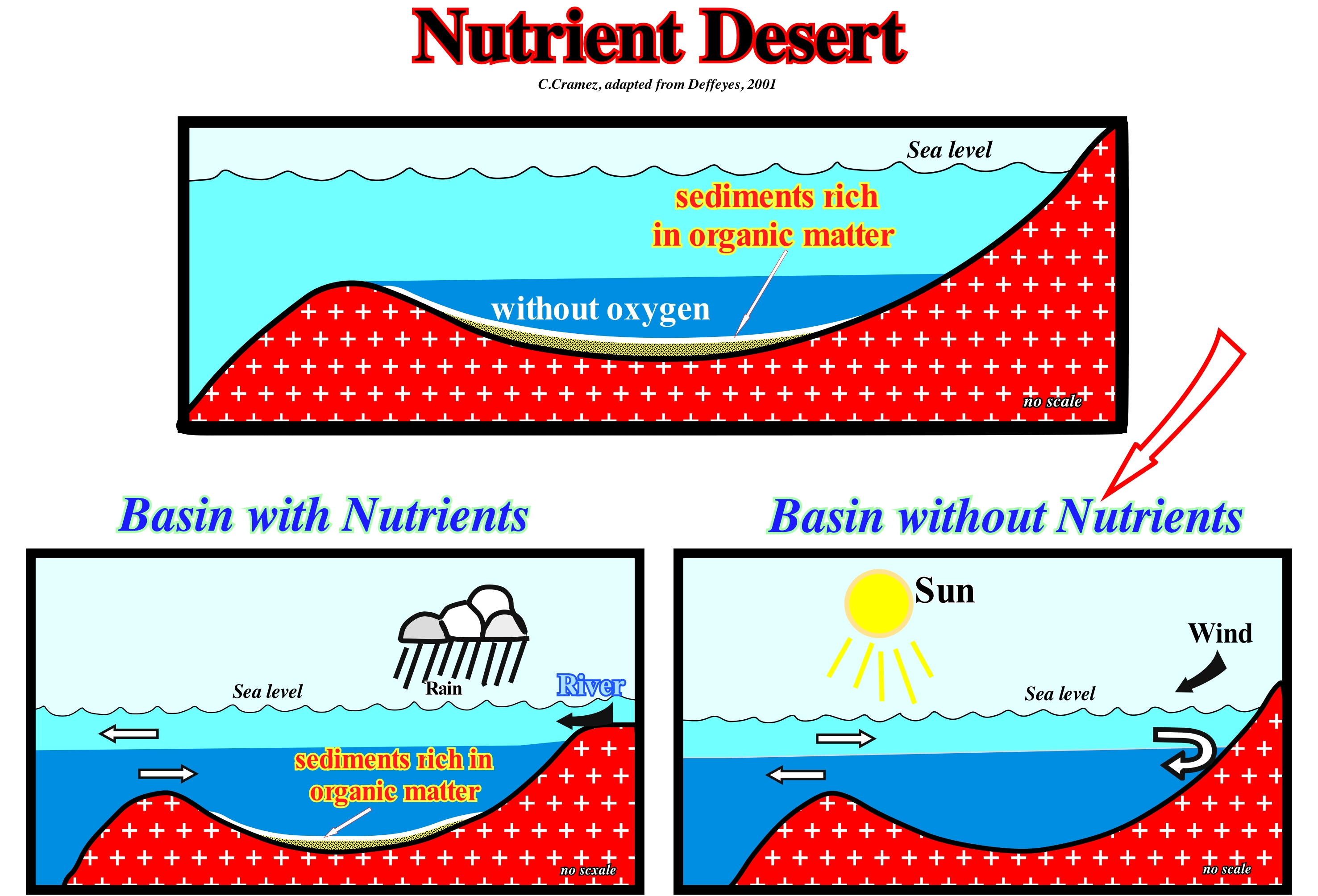
Probably, the two main reasons for explaining the absence of nutrients in a sedimentary basin are: (i) The high oxygen content and (ii) A high basin water temperature. Although the oxygen content of a water-body depends on its temperature, in general, it can be said that oxygen oxidized organic matter and most other nutrients. Since sea-water temperature is above 12° C, most living organisms disappear, transforming the water-body into an organic desert, with the exception of the regions adjacent to the mouths of large rivers or near areas with a very dense population. The diagram on the left-hand side of this figure expresses a conjecture accepted by most geoscientists working in the oil industry, i.e., that in the absence of deep-water circulation, organic matter is preserved, because oxygen at the bottom of the basin is, practically, non-existent. Thus: (i) When the supply of fresh water in a basin, more or less, confined is higher than evaporation, the organic material stays in the basin (nutrient basin) and (ii) When the amount of water lost by evaporation is not compensated by fresh-water, the basin deep-water, which is rich in nutrients, is exported to the ocean and the basin becomes very poor in nutrients. The term basin is here taken in a very general sense, since this type of basins is almost always found on the continental shelves (clastic or carbonated) subject to the action of upwelling marine currents (cold and rich in nutrients ), especially, during transgressive episodes. Thus, when the relative sea level rises and shifts the depositional coastal break of the depositional surface continentward, the distal parts of the continental shelf (near the basin edge) are subject to a very low sedimentation rate, allows an explosion of fauna and flora, especially, when an upwelling cold current is present. The superabundance of living matter will sooner or later produce an oxygen zone depleted, which will favour the preservation of dead organic matter before it is fossilized by the regressive sediments, which generally settle down on top.
(*) Chemicals (nitrogen, potassium, phosphorus, calcium, etc.) that contain food and are necessary for the cells to live.
Nutrient Trap (Nutrient basin).............................................................................................................................Bassin avec nutriants
Bacia com nutrientes / Cuenca con nutrientes / Becken mit Nährstoff / 盆地与营养 / Бассейн с нутриентами, необходимыми для формирования углеводородов / Bacino con nutrienti /
Nutrient-rich basin*. When the water of a more or less confined ocean basin is rich in nutrients. Dead organisms and faecal matter transfer biological nutrients from surface water to deep-water. The circulation of sea water in a more or less confined basin depends on the balance between evaporation and fresh water intake. When evaporation exceeds the intake (rain, rivers, etc.), the nutrient-rich deep water is exported thus forming a confined basin without nutrients. When fresh-water intake is greater than water lost by evaporation, the biological nutrients are retained in the confined basin (nutrient basin), which allows the formation of sedimentary rocks rich in organic matter (potential source-rocks).
See: « Basin (sedimentary) »
&
« Nutrient Desert »
&
« Potential Source-Rock »
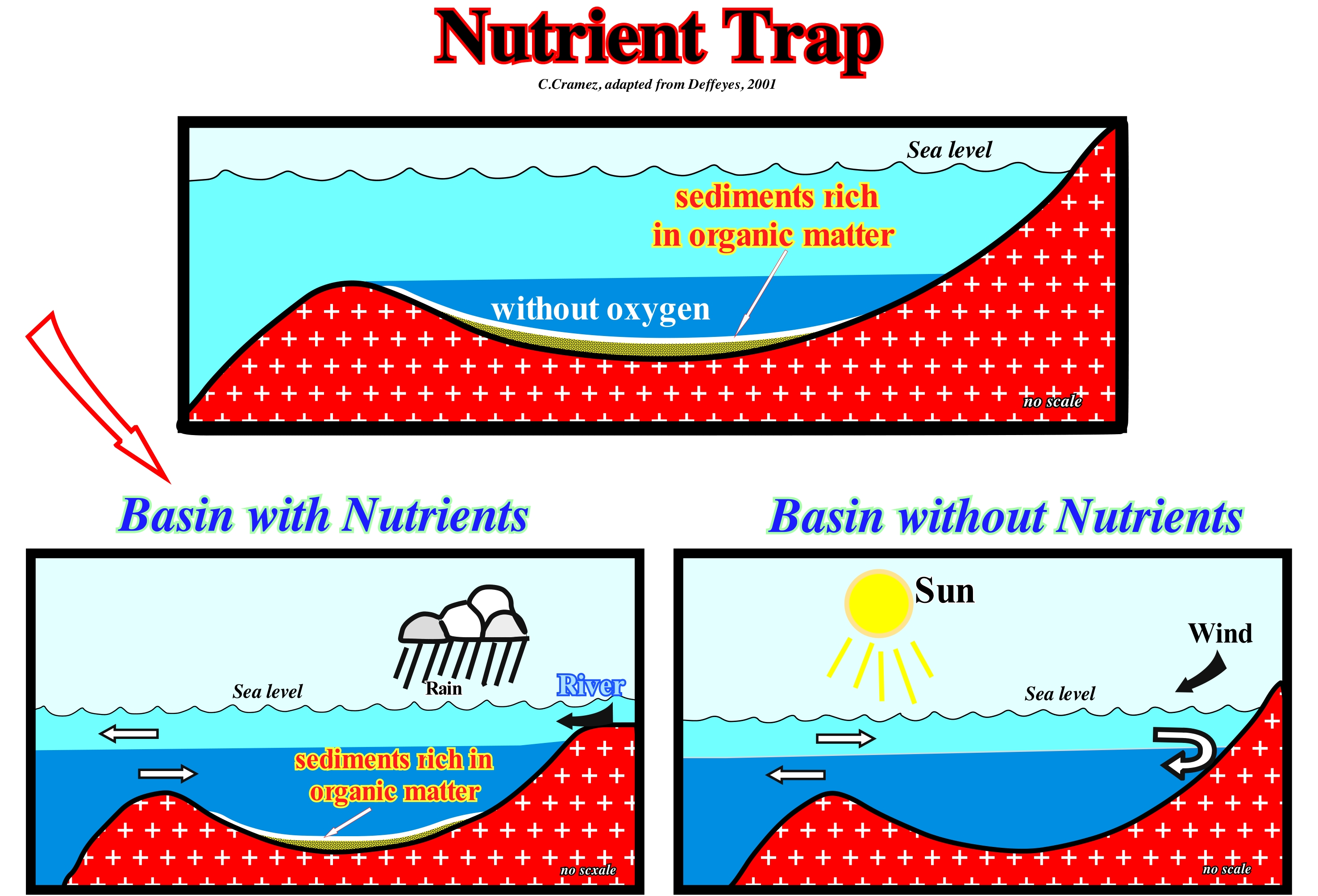
The sketch at the top of this figure illustrates a conjecture accepted by most geoscientists working in the oil industry: "In the absence of deep-water circulation, organic matter is preserved because the oxygen in the bottom of the basin is practically nonexistent". Thus, it can be said when: (i) The fresh-water intake in a, more or less, confined basin is higher than evaporation, the organic material stays in the basin (nutrient basin) and (ii) The amount of water lost by evaporation is not offset by fresh-water, the deep-water of the basin, which is rich in nutrients, is exported to the ocean and the basin becomes very poor in nutrients. The term basin is used here in a very general sense, since it can, often, be found on continental shelves subject to upward currents (especially during transgressive sedimentary episodes). When the relative sea level rises and displaces the depositional coastal break of the depositional surface continentward, the distal portions of the platform (near the basin edge) are subject to a rate of very weak sedimentation, which allows an explosion of fauna and flora, especially, when an upwelling cold current (rich in nutrients) is present. The superabundance of living matter will produce, sooner or later, an area depleted in oxygen, which will favour the preservation of organic matter before it is fossilized.
(*) Chemicals (nitrogen, potassium, phosphorus, calcium, etc.) that contain food and are necessary for the cells to live.

